Pikui weather
Summit 1408 m · Vododilnyi Ridge. Separate forecasts for the summit and the valley (Bilasovytsia, 588 m). About the peak: Pikui
Active official warnings
- Heavy rain — сильний (30-70 мм)
Level 2, orange · 13.11, 10:00 – 20:00 · Закарпатська область - Rain and snow — сильні (30-70 мм)
Level 2, orange · 13.11, 10:00 – 20:00 · Карпати (високогір’я) - Heavy rain — значний (15-30 мм)
Level 1, yellow · 13.11, 10:00 – 20:00 · Львівська область - Strong wind — 15-20 м/с
Level 1, yellow · 13.11, 10:00 – 20:00 · Львівська область, Закарпатська область - Strong wind — 25-30 м/с
Level 1, yellow · 13.11, 10:00 – 20:00 · Карпати (високогір’я) - Blizzard
Level 1, yellow · 13.11, 14:00 – 20:00 · Карпати (високогір’я)
Source: УкрГМЦ, updated at 13.11, 10:00. The official text is on the source site.
Hiking forecast for the route
Bilasovytsia village – Mount PikuiWeekend: Saturday — good, Sunday — goodBest day this week: Saturday, 14 Nov
Not advisedtoday, 13 Nov
Better to postpone the hike
Cold, feels like −12°, rain, about 5 mm and fresh wind up high.
Start at 11:00 → finish around 14:00
- Up high · 1408 m
- −4…−2°feels like −12°
- At the start · 594 m
- −4…+4°feels like −11°
- Precipitation
- Snow ≈ 5 cmduring the hike
- Wind up high
- 34 km/hgusts ≈ 51 km/h (estimate)
- Thunderstorm
- Not expected
- Clouds and visibility
- Summit in cloudpoor visibility
- Snow and ice
- Fresh snow0° at ≈ 850 m
- Daylight
- 7:33 – 16:509 h 16 min of daylight
Hourly up highyour time on the trail is highlighted
Keep in mind
- Cold: feels like −12° up high. Cover your face and hands, keep spare gloves dry.
- Rain — about 5 mm. The path will be wet and slippery on the descents.
- Fresh wind up high — up to 34 km/h. The summit will feel colder than it looks from below.
- Light snow up high — the path may be slippery.
- Clouds and fog up high — poor visibility, views are unlikely. Follow the waymarks and download the track for offline use.
What to take
- Insulated jacket over the fleece — feels like −12° up high
- Warm mittens, hat and buff
- A spare warm layer: from −12° up high to 4° below
- Waterproof jacket — about 5 mm of rain
- Waterproof hiking boots
- Buff and glasses against the wind
- Water: 1 l per person — hardly any springs on the route
- A thermos of hot tea
- A snack: nuts or a bar
- Rain cover for the backpack, things in a dry bag
- Microspikes — in case of ice
- Trekking poles — 814 m of ascent
- Headlamp — sunset at 16:50
- Offline map or the GPX track of this route
- First-aid kit and an emergency blanket
- Charged phone and a power bank
In an emergency call 101 or 112Mountain rescue
GoodSaturday, 14 Nov
A good day for a hike
Dry and wind up high to 17 km/h. But chilly up high (−9°) and icy patches possible in the morning.
Better start at 9:00 → finish around 12:00
- Up high · 1408 m
- −4…−3°feels like −9°
- At the start · 594 m
- −4…+2°feels like −9°
- Precipitation
- Dryduring the hike
- Wind up high
- 17 km/hgusts ≈ 26 km/h (estimate)
- Thunderstorm
- Not expected
- Clouds and visibility
- Summit in cloudcloud from ≈ 1 300 m
- Snow and ice
- Ice possible0° at ≈ 760 m
- Daylight
- 7:35 – 16:499 h 14 min of daylight
Hourly up highyour time on the trail is highlighted
Keep in mind
- Chilly up high — feels like −9°.
- Around zero up high: rocks and roots may be icy in the morning.
What to take
- Insulated jacket over the fleece — feels like −9° up high
- Warm mittens, hat and buff
- A light rain jacket, just in case
- Hiking boots with a good grip
- Water: 1 l per person — hardly any springs on the route
- A thermos of hot tea
- A snack: nuts or a bar
- Microspikes — in case of ice
- Trekking poles — 814 m of ascent
- Headlamp — sunset at 16:49
- Offline map or the GPX track of this route
- First-aid kit and an emergency blanket
- Charged phone and a power bank
In an emergency call 101 or 112Mountain rescue
GoodSunday, 15 Nov
A good day for a hike
Dry, wind up high to 20 km/h and clear — views expected. But chilly up high (−8°) and icy patches possible in the morning.
Better start at 10:00 → finish around 13:00
- Up high · 1408 m
- −3…−1°feels like −8°
- At the start · 594 m
- −2…+4°feels like −7°
- Precipitation
- Dryduring the hike
- Wind up high
- 20 km/hgusts ≈ 30 km/h (estimate)
- Thunderstorm
- Not expected
- Clouds and visibility
- Clearthere will be views
- Snow and ice
- Ice possible0° at ≈ 950 m
- Daylight
- 7:36 – 16:489 h 11 min of daylight
Hourly up highyour time on the trail is highlighted
Keep in mind
- Chilly up high — feels like −8°.
- Around zero up high: rocks and roots may be icy in the morning.
What to take
- Insulated jacket over the fleece — feels like −8° up high
- Warm mittens, hat and buff
- A light rain jacket, just in case
- Hiking boots with a good grip
- Water: 1 l per person — hardly any springs on the route
- A thermos of hot tea
- A snack: nuts or a bar
- Microspikes — in case of ice
- Trekking poles — 814 m of ascent
- Headlamp — sunset at 16:48
- Offline map or the GPX track of this route
- First-aid kit and an emergency blanket
- Charged phone and a power bank
In an emergency call 101 or 112Mountain rescue
GoodMonday, 16 Nov
A good day for a hike
Dry and wind up high to 11 km/h. But chilly up high (−7°) and icy patches possible in the morning.
Start at 8:00 → finish around 11:00
- Up high · 1408 m
- −3…+2°feels like −7°
- At the start · 594 m
- −3…+8°feels like −7°
- Precipitation
- Dryduring the hike
- Wind up high
- 11 km/hgusts ≈ 17 km/h (estimate)
- Thunderstorm
- Not expected
- Clouds and visibility
- Clouds above the summitcloud from ≈ 1 600 m
- Snow and ice
- Ice possible0° at ≈ 1 020 m
- Daylight
- 7:38 – 16:469 h 8 min of daylight
Hourly up highyour time on the trail is highlighted
Keep in mind
- Chilly up high — feels like −7°.
- Around zero up high: rocks and roots may be icy in the morning.
What to take
- Insulated jacket over the fleece — feels like −7° up high
- Warm mittens, hat and buff
- A spare warm layer: from −7° up high to 8° below
- A light rain jacket, just in case
- Hiking boots with a good grip
- Water: 1 l per person — hardly any springs on the route
- A thermos of hot tea
- A snack: nuts or a bar
- Microspikes — in case of ice
- Trekking poles — 814 m of ascent
- Headlamp — sunset at 16:46
- Offline map or the GPX track of this route
- First-aid kit and an emergency blanket
- Charged phone and a power bank
In an emergency call 101 or 112Mountain rescue
GoodTuesday, 17 Nov
A good day for a hike
Wind up high to 13 km/h. But light snow up high, fog up high and chilly up high (−4°).
Start at 8:00 → finish around 11:00
- Up high · 1408 m
- 0…1°feels like −4°
- At the start · 594 m
- 0…7°feels like −4°
- Precipitation
- Snow ≈ 1 cmduring the hike
- Wind up high
- 13 km/hgusts ≈ 20 km/h (estimate)
- Thunderstorm
- Not expected
- Clouds and visibility
- Summit in cloudpoor visibility
- Snow and ice
- Fresh snow0° at ≈ 1 410 m
- Daylight
- 7:39 – 16:459 h 5 min of daylight
Hourly up highyour time on the trail is highlighted
Keep in mind
- Light snow up high — the path may be slippery.
- Clouds and fog up high — poor visibility, views are unlikely. Follow the waymarks and download the track for offline use.
- Chilly up high — feels like −4°.
What to take
- Three layers: base layer, fleece, wind- and waterproof jacket — −4° up high
- Hat and light gloves
- Waterproof jacket — about 1 mm of rain
- Waterproof hiking boots
- Water: 1 l per person — hardly any springs on the route
- A thermos of hot tea
- A snack: nuts or a bar
- Rain cover for the backpack, things in a dry bag
- Microspikes — in case of ice
- Trekking poles — 814 m of ascent
- Headlamp — sunset at 16:45
- Offline map or the GPX track of this route
- First-aid kit and an emergency blanket
- Charged phone and a power bank
In an emergency call 101 or 112Mountain rescue
GoodWednesday, 18 Nov
A good day for a hike
Wind up high to 20 km/h. But rain, about 8 mm and chilly up high (−3°).
Start at 8:00 → finish around 11:00
- Up high · 1408 m
- 2…3°feels like −3°
- At the start · 594 m
- 2…9°feels like −3°
- Precipitation
- Rain ≈ 8 mmduring the hike
- Wind up high
- 20 km/hgusts ≈ 30 km/h (estimate)
- Thunderstorm
- Not expected
- Clouds and visibility
- Overcast
- Snow and ice
- Not expected0° at ≈ 1 720 m
- Daylight
- 7:41 – 16:449 h 3 min of daylight
Hourly up highyour time on the trail is highlighted
Keep in mind
- Rain — about 8 mm. The path will be wet and slippery on the descents.
- Chilly up high — feels like −3°.
What to take
- Three layers: base layer, fleece, wind- and waterproof jacket — −3° up high
- Hat and light gloves
- A spare warm layer: from −3° up high to 9° below
- Waterproof jacket — about 8 mm of rain
- Rain trousers or gaiters
- Spare socks in a waterproof bag
- Waterproof hiking boots
- Water: 1 l per person — hardly any springs on the route
- A thermos of hot tea
- A snack: nuts or a bar
- Rain cover for the backpack, things in a dry bag
- Trekking poles — 814 m of ascent
- Headlamp — sunset at 16:44
- Offline map or the GPX track of this route
- First-aid kit and an emergency blanket
- Charged phone and a power bank
In an emergency call 101 or 112Mountain rescue
GoodThursday, 19 Nov
A good day for a hike
Almost no wind. But light snow up high, fog up high and chilly up high (−4°).
Start at 8:00 → finish around 11:00
- Up high · 1408 m
- −2…−1°feels like −4°
- At the start · 594 m
- −2…+5°feels like −4°
- Precipitation
- Snow ≈ 1 cmduring the hike
- Wind up high
- Almost calm
- Thunderstorm
- Not expected
- Clouds and visibility
- Summit in cloudpoor visibility
- Snow and ice
- Fresh snow0° at ≈ 1 180 m
- Daylight
- 7:42 – 16:439 h 0 min of daylight
Hourly up highyour time on the trail is highlighted
Keep in mind
- Light snow up high — the path may be slippery.
- Clouds and fog up high — poor visibility, views are unlikely. Follow the waymarks and download the track for offline use.
- Chilly up high — feels like −4°.
What to take
- Three layers: base layer, fleece, wind- and waterproof jacket — −4° up high
- Hat and light gloves
- Waterproof jacket — snow up high
- Waterproof hiking boots
- Water: 1 l per person — hardly any springs on the route
- A thermos of hot tea
- A snack: nuts or a bar
- Rain cover for the backpack, things in a dry bag
- Microspikes — in case of ice
- Trekking poles — 814 m of ascent
- Headlamp — sunset at 16:43
- Offline map or the GPX track of this route
- First-aid kit and an emergency blanket
- Charged phone and a power bank
In an emergency call 101 or 112Mountain rescue
Updated at 9:40 · data: MET Norway (CC BY 4.0), model run of 9:19. Temperature recalculated for altitude; wind on an open ridge and gusts marked «≈» are our estimate. A forecast is a guide, not a guarantee: mountain weather changes fast.
Summit and valley
Routes to the summit
 EasyOne-dayMarkedBilasovytsia village Mount PikuiElevation profile594–1 408 m4.5 kmascent 814 m≈ 2.5 h walking
 EasyOne-dayBilasovytsia village Mount PikuiElevation profile594–1 334 m5.3 kmascent 779 m≈ 2.5 h walking
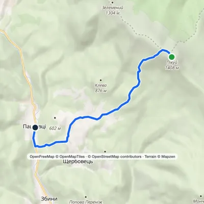 EasyOne-dayMarkedPashkivtsi Mount Pikuivia ShcherbovetsElevation profile458–1 408 m6.8 kmascent 7 m≈ 1.5 h walking
Forecast map
Precipitation, ridge-level wind and freezing level for 5 days; shaded areas are official warnings. Tap a marker for the weather now and tomorrow.
Forecast map: Deutscher Wetterdienst (ICON-EU), CC BY 4.0
Official warnings and services
Check the official warnings before you head into the mountains. Links checked on 12.11.2026.
All summits
Data sources and how we calculate
- Point forecasts — cards, summit pages, route forecastData: MET Norway Locationforecast 2.0 (Norwegian Meteorological Institute). For the Carpathians it is based on the global HRES model of the European Centre for Medium-Range Weather Forecasts (ECMWF): ≈ 9 km grid, 10-day forecast, updated 4 times a day. We request the 0.1° cell around the place and keep the answer up to 3 hours so as not to overload the service. Licence: CC BY 4.0 and NLOD 2.0.
- Our own calculations — estimates, not model outputTemperature is shifted to the real altitude of the place: −0.62 °C per 100 m. The model smooths the mountains, so wind on an open ridge at 1000–2000 m is multiplied by 1–1.5; gusts, when the model has none, are ≈ 1.5 × the wind (marked «≈»). The freezing level on the cards is computed from the temperature at height (−6.5 °C per km). The hiking verdict weighs the start, the highest point and the finish of the route, walking time from length and ascent, and daylight; it accounts for thunderstorms, wind, rain, snow and ice, frost and wind chill, heat and fog. For towns it is a city walk, not a hike.
- ElevationsSummit and place heights come from our checked data and the Copernicus DEM GLO-30 elevation model (≈ 30 m; © DLR, Airbus, EU Copernicus programme and ESA). Where a place has no height, the model terrain height is used.
- Sunrise and sunsetAn astronomical calculation for the place coordinates (PHP date_sun_info) in local time. Mountains on the horizon are not taken into account: in a deep valley the sun rises later.
- Forecast map: precipitation, wind, freezing levelThe ICON-EU model of the German Weather Service (DWD): ≈ 7 km grid, runs at 00 and 12 UTC, forecast to +120 hours; we refresh the map twice a day. Precipitation — rate over the interval and type (snow share); wind — at 800 hPa (≈ 2000 m, ridge height); freezing level — height of 0 °C. Licence CC BY 4.0, source: Deutscher Wetterdienst.
- Official warningsUkraine — Ukrainian Hydrometeorological Center, Poland — IMGW-PIB, Slovakia — SHMÚ (open CAP data, CC BY 4.0). We check every 30 minutes and show them as published: the source is official, we only display it. The Romanian service ANM publishes no open feed, so for Romania there is only a link to the ANM warnings. Avalanche bulletins and mountain rescue are in the «Official services» block.
- Times and «updated at …»All times are the local time of the country: Ukraine and Romania UTC+2 (+3 in summer), Poland and Slovakia UTC+1 (+2 in summer). «Updated at …» is when we last received the data; «model run of …» is the start time of the model run the forecast comes from.
- Limitations and safetyA forecast is a guide, not a guarantee: mountain weather changes fast, and valleys and ridges have their own microclimate. Check the official warnings before you go and tell someone your route. In an emergency: Ukraine 101 or 112; Poland 985 or 601 100 300; Slovakia 18 300; Romania 0725 826 668 (Salvamont) or 112.
