Hoverla weather
Summit 2061 m · Chornohora. Separate forecasts for the summit and the valley (Zaroslyak, 1264 m). About the peak: Hoverla
Summit and valley
Hiking forecast for the route
Zaroslyak base – Mount HoverlaBest day this week: Friday, 9 Oct
Icy patches possible in the morning, dry, wind up high to 8 km/h.
- Start at 8:00 — at the finish around 10:30
- Sunrise 7:29 · sunset 18:49
- 6:000°8 km/h
- 8:000°7 km/h
- 10:005°6 km/h
- 12:007°9 km/h
- 14:008°14 km/h
- 16:007°17 km/h
- 18:006°9 km/h
- 20:003°6 km/h
Warnings
- Around zero up high: rocks and roots may be icy in the morning.
In an emergency call 101 or 112Mountain rescue
What to take
- Three layers: base layer, fleece, wind- and waterproof jacket — −2° up high
- Hat and light gloves
- A light rain jacket, just in case
- Hiking boots with a good grip
- Water: 1 l per person — hardly any springs on the route
- A thermos of hot tea
- A snack: nuts or a bar
- Microspikes — in case of ice
- Trekking poles — 752 m of ascent
- Offline map or the GPX track of this route
- First-aid kit and an emergency blanket
- Charged phone and a power bank
Chilly up high (−4°), dry, wind up high to 18 km/h.
- Start at 8:00 — at the finish around 10:30
- Sunrise 7:31 · sunset 18:47
- 6:000°14 km/h
- 8:001°18 km/h
- 10:006°18 km/h
- 12:008°28 km/h
- 14:009°25 km/h
- 16:009°21 km/h
- 18:006°10 km/h
- 20:004°10 km/h
Warnings
- Chilly up high — feels like −4°.
In an emergency call 101 or 112Mountain rescue
What to take
- Three layers: base layer, fleece, wind- and waterproof jacket — −4° up high
- Hat and light gloves
- A light rain jacket, just in case
- Hiking boots with a good grip
- Water: 1 l per person — hardly any springs on the route
- A thermos of hot tea
- A snack: nuts or a bar
- Trekking poles — 752 m of ascent
- Offline map or the GPX track of this route
- First-aid kit and an emergency blanket
- Charged phone and a power bank
Dry, wind up high to 29 km/h, 5…8° up high.
- Start at 8:00 — at the finish around 10:30
- Sunrise 7:32 · sunset 18:45
- 6:006°37 km/h
- 8:005°28 km/h
- 9–157°29 km/h0.5 mm
- 15–218°18 km/h0.7 mm
- 21–36°9 km/h0.2 mm
Warnings
No special warnings. Have a good hike!
In an emergency call 101 or 112Mountain rescue
What to take
- Three layers: base layer, fleece, wind- and waterproof jacket — 1° up high
- Hat and light gloves
- A spare warm layer: from 1° up high to 14° below
- A light rain jacket, just in case
- Hiking boots with a good grip
- Tick repellent and long trousers; check yourself after the hike
- Water: 1 l per person — hardly any springs on the route
- A thermos of hot tea
- A snack: nuts or a bar
- Trekking poles — 752 m of ascent
- Offline map or the GPX track of this route
- First-aid kit and an emergency blanket
- Charged phone and a power bank
Fog up high, dry, wind up high to 12 km/h.
- Start at 8:00 — at the finish around 10:30
- Sunrise 7:33 · sunset 18:43
- 3–95°10 km/h
- 9–156°12 km/h0.3 mm
- 15–219°18 km/h
- 21–34°5 km/h
Warnings
- Clouds and fog up high — poor visibility, views are unlikely. Follow the waymarks and download the track for offline use.
In an emergency call 101 or 112Mountain rescue
What to take
- Three layers: base layer, fleece, wind- and waterproof jacket — 3° up high
- Hat and light gloves
- A light rain jacket, just in case
- Hiking boots with a good grip
- Tick repellent and long trousers; check yourself after the hike
- Water: 1 l per person — hardly any springs on the route
- A thermos of hot tea
- A snack: nuts or a bar
- Trekking poles — 752 m of ascent
- Offline map or the GPX track of this route
- First-aid kit and an emergency blanket
- Charged phone and a power bank
A little rain possible, almost no wind, 3…6° up high.
- Start at 8:00 — at the finish around 10:30
- Sunrise 7:35 · sunset 18:41
- 3–93°3 km/h3.9 mm
- 9–154°6 km/h4.9 mm
- 15–215°6 km/h4.9 mm
- 21–33°2 km/h
Warnings
No special warnings. Have a good hike!
In an emergency call 101 or 112Mountain rescue
What to take
- Three layers: base layer, fleece, wind- and waterproof jacket — 3° up high
- Hat and light gloves
- Waterproof jacket — about 2 mm of rain
- Hiking boots with a good grip
- Tick repellent and long trousers; check yourself after the hike
- Water: 1 l per person — hardly any springs on the route
- A thermos of hot tea
- A snack: nuts or a bar
- Rain cover for the backpack, things in a dry bag
- Trekking poles — 752 m of ascent
- Offline map or the GPX track of this route
- First-aid kit and an emergency blanket
- Charged phone and a power bank
Fog up high, icy patches possible in the morning, dry.
- Start at 8:00 — at the finish around 10:30
- Sunrise 7:36 · sunset 18:39
- 3–91°6 km/h
- 9–151°4 km/h
- 15–214°10 km/h0.7 mm
- 21–30°8 km/h
Warnings
- Clouds and fog up high — poor visibility, views are unlikely. Follow the waymarks and download the track for offline use.
- Around zero up high: rocks and roots may be icy in the morning.
In an emergency call 101 or 112Mountain rescue
What to take
- Three layers: base layer, fleece, wind- and waterproof jacket — −2° up high
- Hat and light gloves
- A light rain jacket, just in case
- Hiking boots with a good grip
- Tick repellent and long trousers; check yourself after the hike
- Water: 1 l per person — hardly any springs on the route
- A thermos of hot tea
- A snack: nuts or a bar
- Microspikes — in case of ice
- Trekking poles — 752 m of ascent
- Offline map or the GPX track of this route
- First-aid kit and an emergency blanket
- Charged phone and a power bank
Chilly up high (−4°), icy patches possible in the morning, dry.
- Start at 8:00 — at the finish around 10:30
- Sunrise 7:38 · sunset 18:37
- 3–9−2°4 km/h
- 9–15−2°6 km/h0.4 mm
- 15–211°15 km/h
- 21–3−3°4 km/h
Warnings
- Chilly up high — feels like −4°.
- Around zero up high: rocks and roots may be icy in the morning.
In an emergency call 101 or 112Mountain rescue
What to take
- Three layers: base layer, fleece, wind- and waterproof jacket — −4° up high
- Hat and light gloves
- Waterproof jacket — snow up high
- Waterproof hiking boots
- Sunscreen and sunglasses — UV index 1
- Water: 1 l per person — hardly any springs on the route
- A thermos of hot tea
- A snack: nuts or a bar
- Rain cover for the backpack, things in a dry bag
- Microspikes — in case of ice
- Trekking poles — 752 m of ascent
- Offline map or the GPX track of this route
- First-aid kit and an emergency blanket
- Charged phone and a power bank
Forecast: MET Norway (CC BY 4.0), temperature corrected for altitude; wind up high is an estimate for an open ridge. Updated at 21:44. A forecast is a guide, not a guarantee: mountain weather changes fast.
Routes to the summit
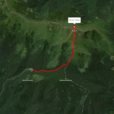 EasyOne-dayMarkedZaroslyak base Mount HoverlaElevation profile1 264–1 994 m3.7 kmascent 752 m≈ 2.5 h walking
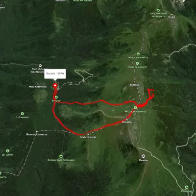 ModerateOne-dayUnmarkedZaroslyak base loopvia Mount Hoverla, Hoverla WaterfallElevation profile1 264–2 042 m10.4 kmascent 944 m≈ 4.5 h walking
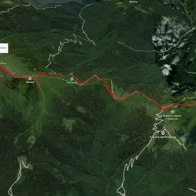 ModerateOne-dayUnmarkedMount Petros Mount HoverlaElevation profile1 492–2 041 m9.9 kmascent 782 m≈ 4 h walking
All summits
How we calculate
The data comes from the Norwegian Meteorological Institute (MET Norway). For every place we request the forecast at its own altitude: Hoverla is usually 8–10° colder than Vorokhta.
The hiking forecast looks at the whole route: start, highest part and finish, walking time from length and ascent, and daylight. It weighs thunderstorms, wind on the open ridge, rain, frost, heat, fog and snow.
It is a guide, not a guarantee. Check the forecast again before you go, tell someone your route, and in an emergency call 101 or 112.
