Dovbushanka weather
Summit 1754 m · Gorgany. Separate forecasts for the summit and the valley (Polianytsia, 902 m). About the peak: Dovbushanka
Summit and valley
Hiking forecast for the route
Polianytsia village – Mount DovbushankaDry, wind up high to 12 km/h, 3…8° up high.
- Start at 8:00 — at the finish around 13:00
- Sunrise 7:30 · sunset 18:50
- 6:000°12 km/h
- 8:001°11 km/h
- 10:006°8 km/h
- 12:009°7 km/h
- 14:0010°12 km/h
- 16:0010°16 km/h
- 18:007°8 km/h
- 20:004°8 km/h
Warnings
No special warnings. Have a good hike!
In an emergency call 101 or 112Mountain rescue
What to take
- Three layers: base layer, fleece, wind- and waterproof jacket — 0° up high
- Hat and light gloves
- A light rain jacket, just in case
- Hiking boots with a good grip
- Tick repellent and long trousers; check yourself after the hike
- Water: 2 l per person — hardly any springs on the route
- A thermos of hot tea
- Lunch and snacks: nuts, dried fruit, chocolate
- Trekking poles — 1082 m of ascent
- Offline map or the GPX track of this route
- First-aid kit and an emergency blanket
- Charged phone and a power bank
Dry, wind up high to 28 km/h, 4…9° up high.
- Start at 8:00 — at the finish around 13:00
- Sunrise 7:31 · sunset 18:48
- 6:001°20 km/h
- 8:002°24 km/h
- 10:007°23 km/h
- 12:0010°28 km/h
- 14:0011°23 km/h
- 16:0010°19 km/h
- 18:008°11 km/h
- 20:004°16 km/h
Warnings
No special warnings. Have a good hike!
In an emergency call 101 or 112Mountain rescue
What to take
- Three layers: base layer, fleece, wind- and waterproof jacket — 0° up high
- Hat and light gloves
- A light rain jacket, just in case
- Hiking boots with a good grip
- Sunscreen and sunglasses — UV index 3
- Tick repellent and long trousers; check yourself after the hike
- Water: 2 l per person — hardly any springs on the route
- A thermos of hot tea
- Lunch and snacks: nuts, dried fruit, chocolate
- Trekking poles — 1082 m of ascent
- Offline map or the GPX track of this route
- First-aid kit and an emergency blanket
- Charged phone and a power bank
Dry, wind up high to 29 km/h, 8…10° up high.
- Start at 8:00 — at the finish around 13:00
- Sunrise 7:33 · sunset 18:46
- 6:008°35 km/h
- 8:007°25 km/h
- 9–158°29 km/h0.5 mm
- 15–2110°16 km/h0.5 mm
- 21–36°2 km/h
Warnings
No special warnings. Have a good hike!
In an emergency call 101 or 112Mountain rescue
What to take
- Three layers: base layer, fleece, wind- and waterproof jacket — 4° up high
- Waterproof jacket — about 1 mm of rain
- Hiking boots with a good grip
- Tick repellent and long trousers; check yourself after the hike
- Water: 2 l per person — hardly any springs on the route
- Lunch and snacks: nuts, dried fruit, chocolate
- Rain cover for the backpack, things in a dry bag
- Trekking poles — 1082 m of ascent
- Offline map or the GPX track of this route
- First-aid kit and an emergency blanket
- Charged phone and a power bank
Dry, wind up high to 8 km/h, 6…11° up high.
- Start at 8:00 — at the finish around 13:00
- Sunrise 7:34 · sunset 18:44
- 3–96°2 km/h
- 9–156°8 km/h
- 15–2111°18 km/h
- 21–34°6 km/h
Warnings
No special warnings. Have a good hike!
In an emergency call 101 or 112Mountain rescue
What to take
- Three layers: base layer, fleece, wind- and waterproof jacket — 5° up high
- A spare warm layer: from 5° up high to 18° below
- A light rain jacket, just in case
- Hiking boots with a good grip
- Tick repellent and long trousers; check yourself after the hike
- Water: 2 l per person — hardly any springs on the route
- Lunch and snacks: nuts, dried fruit, chocolate
- Trekking poles — 1082 m of ascent
- Offline map or the GPX track of this route
- First-aid kit and an emergency blanket
- Charged phone and a power bank
Rain, about 4 mm, almost no wind, 5…6° up high.
- Start at 8:00 — at the finish around 13:00
- Sunrise 7:36 · sunset 18:42
- 3–94°7 km/h4.4 mm
- 9–155°2 km/h5.3 mm
- 15–215°4 km/h3.6 mm
- 21–33°2 km/h
Warnings
- Rain — about 4 mm. The path will be wet and slippery on the descents.
In an emergency call 101 or 112Mountain rescue
What to take
- Three layers: base layer, fleece, wind- and waterproof jacket — 5° up high
- Waterproof jacket — about 4 mm of rain
- Waterproof hiking boots
- Tick repellent and long trousers; check yourself after the hike
- Water: 2 l per person — hardly any springs on the route
- Lunch and snacks: nuts, dried fruit, chocolate
- Rain cover for the backpack, things in a dry bag
- Trekking poles — 1082 m of ascent
- Offline map or the GPX track of this route
- First-aid kit and an emergency blanket
- Charged phone and a power bank
Fog up high, dry, almost no wind.
- Start at 8:00 — at the finish around 13:00
- Sunrise 7:37 · sunset 18:40
- 3–91°4 km/h
- 9–151°3 km/h0.2 mm
- 15–215°9 km/h
- 21–30°7 km/h
Warnings
- Clouds and fog up high — poor visibility, views are unlikely. Follow the waymarks and download the track for offline use.
In an emergency call 101 or 112Mountain rescue
What to take
- Three layers: base layer, fleece, wind- and waterproof jacket — 1° up high
- Hat and light gloves
- A light rain jacket, just in case
- Hiking boots with a good grip
- Tick repellent and long trousers; check yourself after the hike
- Water: 2 l per person — hardly any springs on the route
- A thermos of hot tea
- Lunch and snacks: nuts, dried fruit, chocolate
- Trekking poles — 1082 m of ascent
- Offline map or the GPX track of this route
- First-aid kit and an emergency blanket
- Charged phone and a power bank
Icy patches possible in the morning, dry, almost no wind.
- Start at 8:00 — at the finish around 13:00
- Sunrise 7:39 · sunset 18:38
- 3–9−1°6 km/h
- 9–15−1°5 km/h0.2 mm
- 15–213°13 km/h
- 21–3−2°2 km/h
Warnings
- Around zero up high: rocks and roots may be icy in the morning.
In an emergency call 101 or 112Mountain rescue
What to take
- Three layers: base layer, fleece, wind- and waterproof jacket — −2° up high
- Hat and light gloves
- Waterproof jacket — snow up high
- Waterproof hiking boots
- Sunscreen and sunglasses — UV index 1
- Tick repellent and long trousers; check yourself after the hike
- Water: 2 l per person — hardly any springs on the route
- A thermos of hot tea
- Lunch and snacks: nuts, dried fruit, chocolate
- Rain cover for the backpack, things in a dry bag
- Microspikes — in case of ice
- Trekking poles — 1082 m of ascent
- Offline map or the GPX track of this route
- First-aid kit and an emergency blanket
- Charged phone and a power bank
Forecast: MET Norway (CC BY 4.0), temperature corrected for altitude; wind up high is an estimate for an open ridge. Updated at 21:41. A forecast is a guide, not a guarantee: mountain weather changes fast.
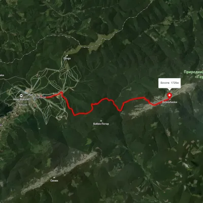
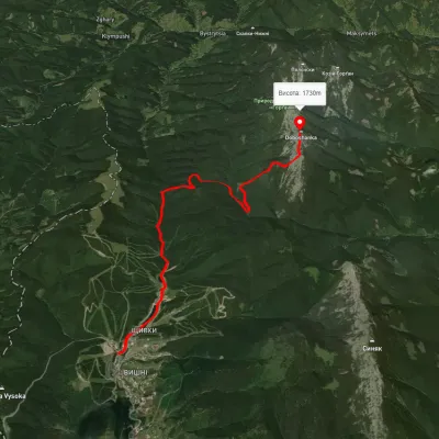
Routes to the summit
All summits
How we calculate
The data comes from the Norwegian Meteorological Institute (MET Norway). For every place we request the forecast at its own altitude: Hoverla is usually 8–10° colder than Vorokhta.
The hiking forecast looks at the whole route: start, highest part and finish, walking time from length and ascent, and daylight. It weighs thunderstorms, wind on the open ridge, rain, frost, heat, fog and snow.
It is a guide, not a guarantee. Check the forecast again before you go, tell someone your route, and in an emergency call 101 or 112.
