Chernivtsi region
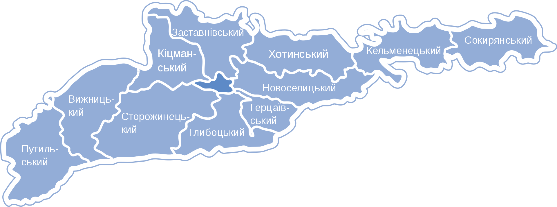
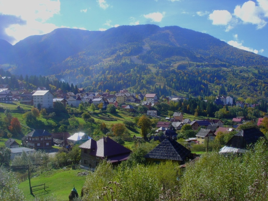
Chernivtsi region is a region in the southwestern part of Ukraine. It was formed on August 7, 1940, from the northern, predominantly Ukrainian-populated part of Bukovyna and the neighboring part of Bessarabia (with Khotyn). The region is located within the Carpathians, Predkarpattya (Bukovyna Prykarpattya) and Pokutsko-Bessarabian Upland. The region borders Romania to the south and Moldova to the southeast. To the west and northwest, it borders Ivano-Frankivsk Oblast, to the north, Ternopil and Khmelnytskyi Oblasts, and to the east, Vinnytsia Oblast. It is the smallest region in Ukraine by area, with Chernivtsi as its regional center. The main tourist districts of the region are Hlybotskyi, Kelmenetskyi, Sokyryanskyi, Storozhynetskyi, Putylskyi, Kitsmanskyi and Vyzhnytskyi, as well as the cities of Khotyn and Chernivtsi, where you can choose accommodation in the private or hotel sector.
As of January 1, 2010, the population of Chernivtsi region amounted to 904.4 thousand people. There are more than 70 rivers in the region that belong to the Danube and Dniester basins. The Dniester, Prut, Seret, and Cheremosh form the basis of the region's river system.
There are 243 territories and objects of the nature reserve fund in the Chernivtsi region, including 7 nature reserves, 8 natural monuments, the Botanical and Dendrological Park of the Chernivtsi National University, and the Vyzhnytsia National Nature Park, Cheremosh National Nature Park, and Storozhynets Dendrological Park, which are of national importance and are part of the transnational ecological network of the Carpathians (TACIS project), as well as 136 natural monuments, 40 parks that are monuments of landscape art, and 39 protected tracts of local importance. The nationally important nature reserves include landscape reserves in Luzhky, Stebnyk, Tsetsyno, the Dranitsky ornithological reserve, and the Lunkivsky and Petrivetsky forest reserves. Natural monuments of national importance include the Shylivskyi Forest, Rukhotynskyi Forest, Tysovyi Yar, Bilka tracts; Bukovynka, Popelushka, Balamutivska caves and other protected areas, among others: Kadubivska wall, Tovtrovska wall, Sovytski marshes, Chornopotocki reserve, Chornyi Dil reserve, Borgynia reserve, Molochnobratskyi karst massif.
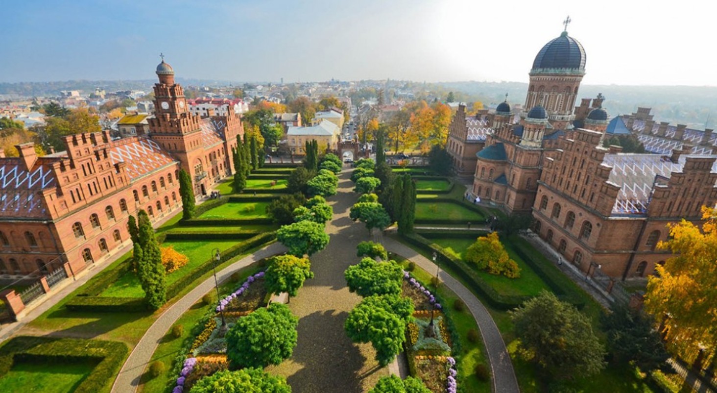
On the territory of Chernivtsi region there are: 836 archeological monuments (including 18 of national importance), 586 historical monuments (including 2 of national importance), 779 architectural and urban planning monuments (including 112 of national importance), and 42 monumental art monuments. The List of Historical Settlements of Ukraine, approved by the Cabinet of Ministers of Ukraine on July 26, 2001, No. 878, includes 11 settlements of the Chernivtsi region: Vyzhnytsia, Hertsa, Hlyboka, Kelmentsi, Kitsman, Luzhany, Novoselytsia, Putyla, Storozhynets, Khotyn, and Chernivtsi.
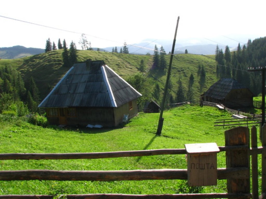
The Chernivtsi region is a fertile area for multidisciplinary summer and winter mountain sports tourism, mass cognitive and recreational recreation, and balneological treatment.
Due to its geographical location, rich recreational resources, and economic potential, Chernivtsi Oblast is an attractive region for the development of interregional and international cooperation.
The construction of four tourist complexes in Transnistria is in progress: in the village of Dnistrovka, Kelmenets district, the first yacht club in the region has already been opened, and in January 2006 the Elena Dibrova complex in the village of Valya Kuzmina, Hlyboka district, was launched. A new tourist complex was opened in the village of Myhove, Vyzhnytsia district. Recreational and tourist entertainment complexes in Bukovyna operate in the Tsetsyno neighborhood in Chernivtsi, in the village of Horbova in the Hertsaiv district, on the Nimchych pass in the Vyzhnytsia district, and in the village of Hlybochok in the Storozhynets district. More than 100 rural tourism sites also welcome tourists.
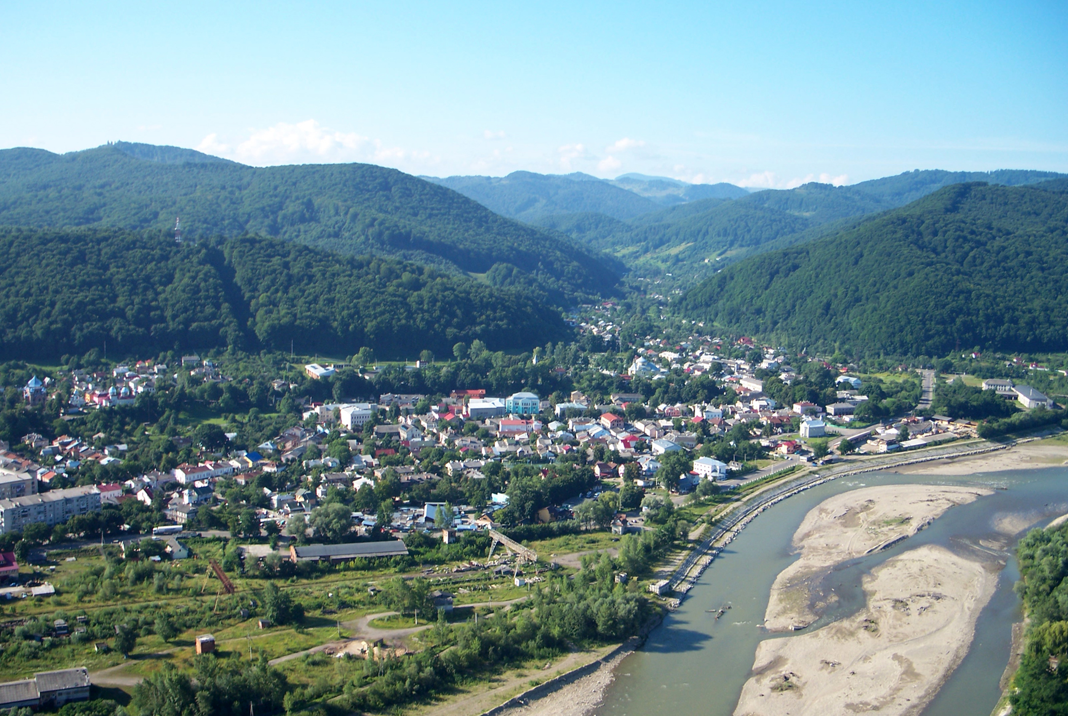
The extraordinary contrast of natural landscapes is due to the physical and geographical location of the region. Chernivtsi region can be divided into parts: the plain area between the Prut and Dniester rivers, the mountainous Bukovyna Carpathians, and the hilly Predkarpattia, which is in between. The Prut-Dniester interfluve is an undulating plain 200-300 meters above sea level. In its central part, there is the Khotyn Upland, an asymmetrical hilly ridge that stretches from Chernivtsi to Khotyn, as well as the highest point of the plain part of Ukraine, Mount Berda (515 meters).
Within Predkarpattia, there is the interfluve of the Prut and Seret rivers, which is occupied by the Chernivtsi Upland with its highest point, Mount Tetsyno (537 m), as well as the Bukovyna Pidhiria. The Bukovyna Carpathians are composed mainly of low mountain ranges up to 1600 meters high. The highest point is Mount Yarovytsia (1574 m). Above 1400 m rise the peaks of Chornyi Dil (1454 m), Semenchuk (1465 m) and Zhupany (1484 m).
The climate of the Chernivtsi region is temperate continental, with an average annual temperature ranging from +8°C in the northeast to +3°C in the southwest. The annual precipitation in the plains is 500-650 mm, and in the upper reaches of the mountains - 1000-1200 mm.
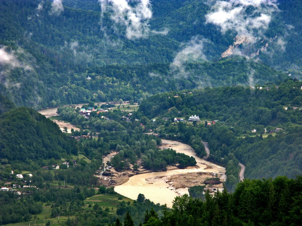
More than 4,000 rivers with a total length of about 9,000 km flow through Chernivtsi region, which belong to the Dniester and Danube basins. The largest river, which forms the border between Chernivtsi and neighboring northern regions, is the Dniester. The Prut river flows through Chernivtsi and the rest of the region, and the Cheremosh and Seret mountain rivers flow through deep valleys and gorges.

- Bukovyna waterfalls are a group of waterfalls on the Smuhariv stream (a tributary of the Cheremosh). The highest one is 19 meters high. Easily accessible, a popular tourist attraction (Putyla district);
- Suceava Hook - about 6 m high. On the Suceava River (Danube basin). It is the most powerful waterfall in the Chernivtsi region due to its water content. It is easily accessible (Putyla district);
- Chemernarskyi Huk - about 4 meters high. On the Zubrynets stream (Chemernar). Easily accessible, little known (Vyzhnytsia district);
- Chemernarskyi Nyzhniy Huk - Height about 2.5 m. On the Zubrynets stream (Chemernar). Easily accessible, little known (Vyzhnytsia district);
- Lopushnyansky waterfalls - a cascade of waterfalls and rapids with a total height of about 14 m. On the Lapushna stream (Siret basin) and its left tributary. Easily accessible, little known (Vyzhnytsia district);
- Luzhky - Vyzhenka river, on the territory of the Luzhky landscape reserve;
- Biskiv - 3 m high, on the Biskiv River. Easily accessible, little known (Putyla district);
- Kizia - about 12 m high. On one of the right tributaries of the Biskiv River. Easily accessible, little known (Putyla district);
- Siruchok - Height 2.5 m. At the mouth of Siruchok stream (left tributary of Tovarnytsia river). Geological natural monument. Easily accessible, little known (Putyla district);
- Korolivskyi - height 3 m. On the Dmytrytsia River (tributary of Malyi Seret). Easily accessible, little known (Storozhynets district);
- Yalovychera Waterfall - on the Yalovychera River (a tributary of the White Cheremosh, near the village of Nyzhniy Yalovets). Easily accessible, little known (Putyla district);
- Porkulyn - Height 6 m. On Porkulyn stream (tributary of Putylka). Easily accessible, little known (Putyla district);
- Chornopototskyi - Geological natural monument. On the Chornyi Potik River (a tributary of the Onut). Easily accessible, little known (Zastavniv district);
- Kulivetskyi - Zastavnivskyi district, Kulivtsi village.
- Doroshivetskyi - height about 6 m. On Tovtryansko-Doroshivetskyi stream (right tributary of Dniester). Geological natural monument. Easily accessible, little known (Zastavna district);
- Falynskyi - Cascade of waterfalls on the Falynskyi stream (right tributary of the Tovtryansko-Doroshovetskyi stream). Geological natural monument. Easily accessible, little known (Zastavna district);
- Vasylivski waterfalls - two waterfalls on the Chunkivskyi Stream (right tributary of the Dniester). Geological natural monument. Easily accessible, little known (Zastavna district);
- Hryniatskyi - a cascade of waterfalls, the total height of all cascades is 34 meters. Easily accessible, little known (Khotyn district);
- Mala Loza - 8 m high. Geological natural monument (since 2008). In the upper reaches of Laura River (tributary of Suceava). Hardly accessible, little known (Storozhynets district).
Chernivtsi region is rich in natural tourist and recreational resources. The average emission of harmful substances in the region's air is five times lower than in the rest of Ukraine. The favorable climate, combined with a high rate of forest cover, creates the necessary conditions for people with respiratory diseases to relax. Chernivtsi region is also rich in healing waters and deposits of therapeutic mud. More than 60 mineral water deposits are known, including Izhevska, Matsesta, Borzhomi, and Naftusia. Three balneological resorts operate on the basis of mineral springs in Chernivtsi, Brusnytsia, and Shcherbinka.
Pokutsko-Bukovyna Carpathians
The Pokutsko-Bukovyna Carpathians cover the territory of Putyla, half of Vyzhnytsia and part of Storozhynets districts of Chernivtsi region.
A large number of picturesque rocks along the beds of large rivers (Cheremosh, Putyla) are fascinating. The most popular rocks among tourists are the Stone Rich Man (near the village of Dykhtynets on the bank of the Putyla River), the Frog (near the village of Marynychi on the bank of the White Cheremosh River), and the Dovbush Rock and Cave (near the village of Pidzakharychi).
The climate in the Pokutsko-Bukovyna Mountains is much milder than in other parts of the Ukrainian Carpathians. This is due to the lower absolute altitudes of the mountain ranges located in Bukovyna. The number of rainy days in the Pokutsko-Bukovyna Carpathians, especially in summer, is much lower than in the Carpathian highlands, which facilitates the organization of hiking trips of a relatively low level of difficulty.
Within the Chernivtsi region, the Carpathian Mountains stretch along parallel ridges from northwest to southeast in four large massifs. The Pokutsko-Bukovyna ranges are located in the watershed between the basins of the Seret and Putyla rivers. The highest peak of the mountain range is Mount Rotylo, which is 1483 meters high.
The Putyla Ridge is located in the southwestern part of Chernivtsi Oblast. Unlike the Pokutsko-Bukovyna ranges, the absolute height of the range is higher and the slopes are steeper. The highest point, Mount Losova, is located at an altitude of 1428 meters.
The Yarovets Ridge is located in the southwestern part of the region. Its relief is represented by dome-shaped peaks with steep rocky slopes. The highest point of the Yarovets Ridge is the peak of Yarovytsia with a height of 1574 meters.
The spurs of the Chyvchyn Mountains occupy the extreme southwestern part of the Chernivtsi region. They form a distinctive ridge that stretches for about 40 km from northwest to southeast, from Mount Stih to Mount Hnatasya, between the valleys of the Black Cheremosh (in the northeast) and the Vaser and Ruskova rivers (in the southwest). The highest peak is the basalt mountain Chyvchyn (1769 m). On the slopes of the Chyvchyn peaks, limestone rocks sometimes appear.
Interesting facts
- The highest peak of the plain part of Ukraine, Mount Berda, 515 meters high, is located on the Khotyn Upland.
- One of the most famous castles in Ukraine is the Khotyn Fortress, which has served as a backdrop for many historical films.
- Tovtrova Ridge in the Bukovyna Carpathians is famous for its unique coral reefs on land.
- The Cinderella Cave is the only place in Ukraine where an underground corridor was naturally formed to cross the state border of Ukraine.
- The village of Selyatyn is the record holder in Ukraine for the number of stormy days (about 45 per year). The village is also famous for the longest thunderstorm in Ukraine - 37 hours: it began on June 10, 2008 at 15:30 and ended on June 12 at 4:30.
- In Ukraine, only Berehomet Arboretum has two trees of the golden larch, which can be seen in its natural environment only in the Yangtze River Delta in China.
- The Zubrovytsia Nature Reserve is the only place in Ukraine where bison live.
- The Vyzhnytsia National Nature Park is the only place in the Ukrainian Carpathians where all three known species of ferns grow - spiky, spear-shaped and Brown's fern.
- Three Shevchenko willows grow at the highest point of the Storozhynets arboretum. During his exile in Kazakhstan, Kobzar grew a willow from a simple poke that reminded him of his homeland. In 1964, the cuttings of this willow were brought to Lviv by Kazakh guests, and 4 years later they were transported to the Storozhynets Arboretum.
- Shurdyne is the highest automobile pass in Ukraine. Its height is 1173 meters above sea level.
- Chernivtsi region is the birthplace of famous Ukrainian singers Volodymyr Ivasyuk, Nazariy Yaremchuk, Sofia Rotaru, Ani Lorak, actor Ivan Mykolaychuk, and the first Ukrainian cosmonaut Leonid Kadenyuk.
- The only roller coaster in Western Ukraine is located in the Zorepad amusement park in the village of Boyany near Chernivtsi.
- The highest village in Ukraine is Vypchyna (1100 meters).
- The Hertsa district is the smallest in Ukraine in terms of territory, and the city of Hertsa is the smallest district center in terms of population. Another feature of the town and the district is its Romanian-speaking population: over 90% of the population speaks Romanian.
- The village of Bila Krynytsia is a world-wide spiritual and historical center of the Old Believers.
- In the village of Davydivka (unofficially called Davydyny) there are 7 wooden churches, most of which are of great interest to researchers of wooden architecture.
- The most colorful folk festival in Bukovyna is the celebration of Malanka or Pereberia. It begins on January 13 and lasts until the evening of the next day. With its incredible costumes and fun, it is somewhat reminiscent of European carnivals.
- The legendary building of the district police department on R. Shukhevycha Street in Vyzhnytsia served as a brothel during the Romanian rule and later as a restaurant.
- In Krasnoilsk, on the southern outskirts of the Slatyn corner, there is a unique well 12 meters deep, and the salt concentration in it is so strong that a chicken egg does not sink in the water.
- The Chernivtsi region is also famous for its Bukovyna embroideries, which are richly decorated with floral motifs.