Lake Vorozheskaya
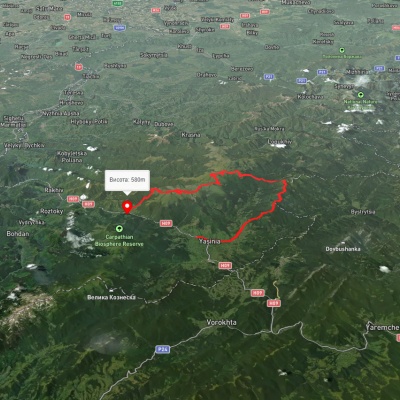
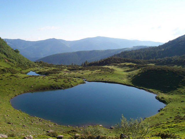
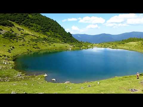
The real pearl of the Carpathians - Lake Vorozheska (other names - Vorozheska, Triton ) - is a hydrological natural monument of local importance, a high-mountain lake of glacial origin in the Ukrainian Carpathians at an altitude of 1460 m. It is located within the Rakhiv district of the Zakarpattia region, in the Carpathian Biosphere Reserve on the Svydovets massif. The NGO "Carpathian Trails" has installed a protective sign near the lake.
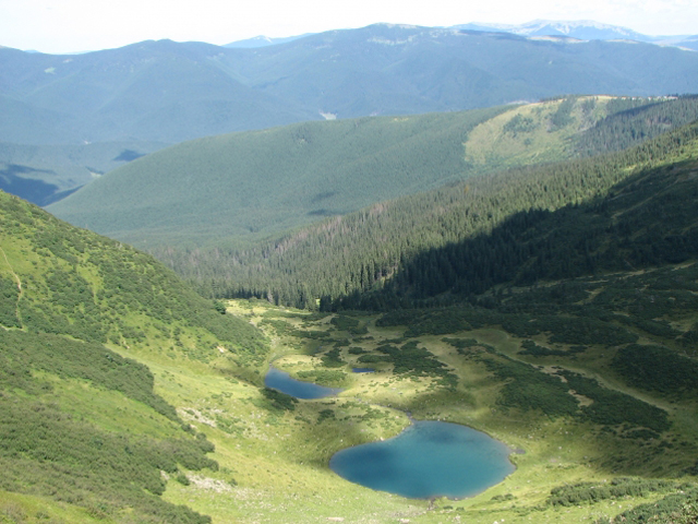
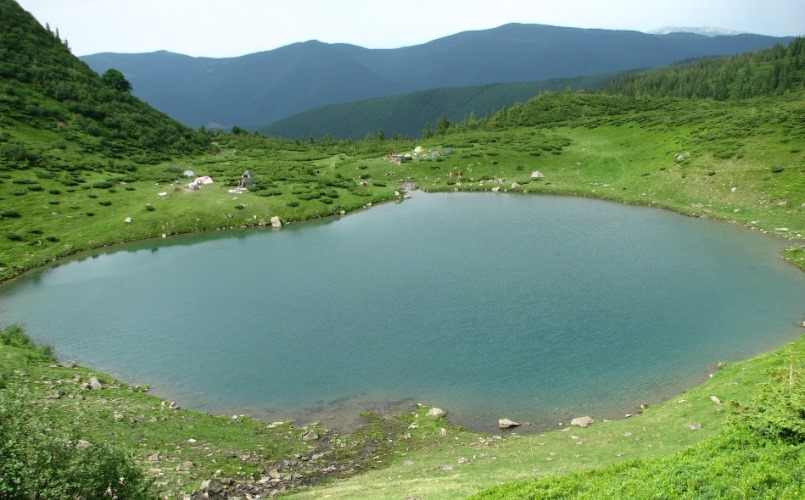
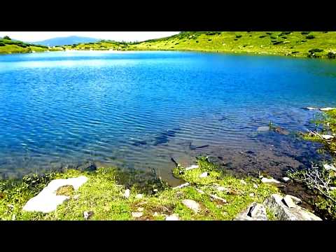
It consists of two small reservoirs. The upper (larger) lake has a round shape (diameter 95 m, area 0.7 hectares, depth up to 4.5 m). The lower lake, located 15 meters below the upper lake, is elongated (length 76 m, width 28 m, area about 0.2 hectares, depth up to 1.9 m). It is fed by a stream that originates in a snowfield composed of firn ice, which melts completely only in the hottest years. The water in the lake is clear, very transparent; its temperature reaches +12 in summer. The bottom is sloping and silted. The fauna is represented by some species of microscopic crustaceans. It is a tourist attraction.
To the west of Vorozheska is Lake Apshinets, to the southwest is Lake Dogyaska, to the southeast is Mount Bolshoi Kotel (1771 m). The nearest settlement is the village of Chorna Tysa. There are colorful villages nearby: Kvasy, Yasinya, Rakhiv. They will acquaint you with the mysterious culture of the Hutsuls: their clothes, way of life, customs and, of course, delicious dishes. Nearby is also a beautiful waterfall Trufanets, whose cold waters will give you strength and vigor.
Vorozheske is endangered because of the snowfield that feeds the reservoir. On the hottest summer days, the snowpack melts completely. And since global warming is expected, don't miss this unique opportunity to see the lake. Thanks to the power source, the water in the reservoir is crystal clear and so transparent that you can see the bottom even through a sufficient depth. According to scientists, Vorozheske was formed due to the movement of ice that covered the land during permafrost. But, as it turned out, permafrost is not eternal, and the melting ice dug pits on its way. They were filled with ice, which turned into water with every warmer day. This is how the glacial lakes were formed, clear as an elephant's eye.
Despite its high location, the lake is surrounded by lush vegetation. Here you can find carpets of spring primrose, thickets of pine, green alder and others. There are also rare three-split sytnik, evergreen sedge and lying fescue. Lush and juicy herbs attract human livestock. Sheep, horses and cows are frequent visitors to the surrounding meadows.
Scientists explained the origin of the reservoir, and people came up with the name. There are two versions of its origin.
One of them tells about two inseparable friends who were grazing flocks of human sheep. But a disaster happened - the boys were caught in a terrible storm, and one of them fell from a high slope. His faithful friend could not leave his friend in trouble and went in search of him. Not only did he fail to save his friend, but he got into trouble himself - the poor man froze to death. At the place where the faithful comrades died, lakes were formed, which got their names because of the hostility of this place.
Another story is about love. Two brothers fell in love with one girl, Marichka. Until that moment, nothing could destroy friendship and brotherly love. To resolve this issue amicably, the brothers decided to swim across a mountain lake. The first one to do it would be Marichka's. But a terrible storm came out of nowhere, stirring up big waves on the lake, which drowned the boys. After learning the truth from the shepherds, the grieving mother rushed to the lake. Her grief knew no bounds, she cried and whispered doomedly: "Why are you, lake, so hostile to me?"
Since then, people have nicknamed the reservoir the Lake of Enemies. And it seems to confirm it every time. During one day at the lake, you can feel a thunderstorm, hail, heat, and see snow.
Hundreds of tourists visit the lake every year and experience its hostile attitude, but this does not break their spirit. On the contrary, it hardens them and makes them as strong as flint. You can get to Lake Vorozheska via three main marked tourist routes:
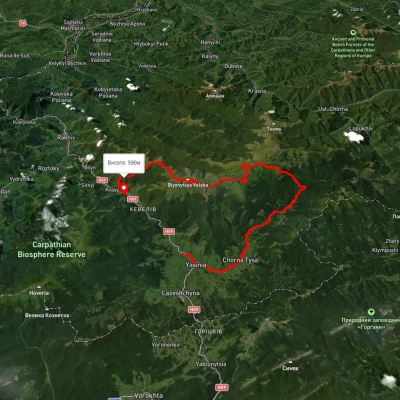
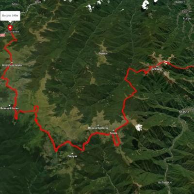
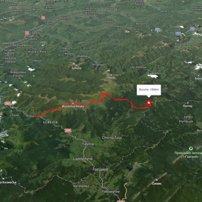
- From the village of Kvasy (red route): we start a slow ascent, walking along a forest path up to the Braivka meadow. From there, we go to the Svydovets ridge, move along the ridge to the north to the Stremcheska meadow. Then we climb to the Blyznytsia mountain (1872m) and immediately after it we reach the Blyznytsia Velyka mountain (1881m). We continue along the ridge in the direction of Peremyshka (1554m). On Peremyshka you will see Dragobrat, and it is from here that the route will start for those who will climb from this village. Then the route goes through the Stig mountain (1704m) and reaches the Gerishaska meadow. Just beyond the meadow, further along the ridge, you will see a sharp descent and a lake at the foot of this descent. If you wish, you can stop your route here, or go a little further along the ridge to the larger lake Gerishaska (otherwise known as Dogyaska). You can return from Lake Vorozheska either by the same way or by going down the path to the village of Chorna Tysa.
- From the village of Yasinia (yellow route): the route starts at the end of the village. You need to move along the Svydovets River to the northwest to Dragobrat. Then climb to Peremyshka, from where the route duplicates the red one.
- From the village of Yasinya (green route): start from the Strukivska church and follow the green markings to Dragobrat. Then the route duplicates the red one.
- The easiest way to the reservoir is from the village of Chorna Tysa. You can get to the village by transport, and from there, after a 5 km hike, Lake Vorozheska awaits you.
If you are making a one-day trip from Dragobrat and then intend to return, it is advisable to take a light snack with you and take care of comfortable shoes. In case of a full-fledged hiking route, it is important to have basic hiking equipment (tent, backpack, sleeping bag, hiking boots (or comfortable sneakers), optional trekking poles), you also need to take enough food, dishes, water containers, a burner, etc. In summer, you may not need warm clothes, but raincoats are a must.
The weather in the Carpathians can be changeable during your stay on the lake. However, this shouldn't spoil your vacation experience in the Carpathians. You just need to prepare for the hike in advance, taking basic hiking equipment, burners and gas cylinders with you, as it can be difficult to find firewood for a fire.
From Lake Vorozheska, you can continue along the Svydovets ridge to Mount Tataruka (1707 m), where you can see Lake Apshynets. From Mount Tataruka, go down to the Ripta meadow, then through the Okole pass to the Gorgany massif, to Mount Bratkivska (1788 m). Then move along the Gorgany massif.
The shortest way to the resort is from the village of Yasinya, which can be reached in the following ways:
- by train to Ivano-Frankivsk and then by bus to Yasinya;
- by train to the village of Yasinya by the Kyiv-Rakhiv connection;
- by train or bus to the village of Yasinia by the Lviv-Rakhiv connection.
From the village of Yasinya to Dragobrat can be reached only by a four-wheel drive car. Fortunately, this type of transport is quite common in this area and you can easily order it from locals or by going to the Edelweiss recreation center.
If you are traveling from Kyiv, it is best to stick to the route: Kyiv-Zhytomyr-Rivne-Dubno-Kremenets-Ternopil-Druzhba-Buchach-Monastyrka-Tysmenytsia-Frankivsk-Nadvirna-Deliatyn-Yaremcha-Yablunytsia-Yasinia.
If you are traveling from Lviv, then stick to the route: Lviv-Rohatyn-Frankivsk-Nadvirna-Deliatyn-Yaremcha-Yablunytsia-Yasinia.
Accommodation around Lake Vorozheskaya:


Which trails pass by Lake Vorozheskaya?
We suggest these hiking trails through or near Lake Vorozheskaya: Chorna Tysa village, via Mount Dohiaska, Mount Velykyi Kotel and Mount Blyznytsia to Kvasy village, Yasinia, via Mount Tataruka, Mount Dohiaska, Mount Stih and Mount Blyznytsia to Kvasy village, Dubove village, via Mount Apetska, Mount Dohiaska, Mount Stih and Mount Blyznytsia to Kvasy village, Kvasy village, via Mount Blyznytsia, Mount Velykyi Kotel and Mount Dohiaska to the Yablunytsia Pass, Yasinia, via Mount Chorna Kleva, Mount Bratkivska, Mount Dohiaska and Mount Blyznytsia to Kvasy village, Yasinia, via Dragobrat, Mount Stih, Mount Velykyi Kotel and Chorna Tysa village to Yasinia

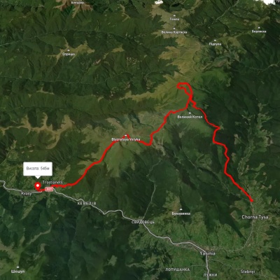
Chorna Tysa village, via Mount Dohiaska, Mount Velykyi Kotel and Mount Blyznytsia to Kvasy village
Yasinia, via Mount Tataruka, Mount Dohiaska, Mount Stih and Mount Blyznytsia to Kvasy village
Dubove village, via Mount Apetska, Mount Dohiaska, Mount Stih and Mount Blyznytsia to Kvasy village
Kvasy village, via Mount Blyznytsia, Mount Velykyi Kotel and Mount Dohiaska to the Yablunytsia Pass