Storozhynets district
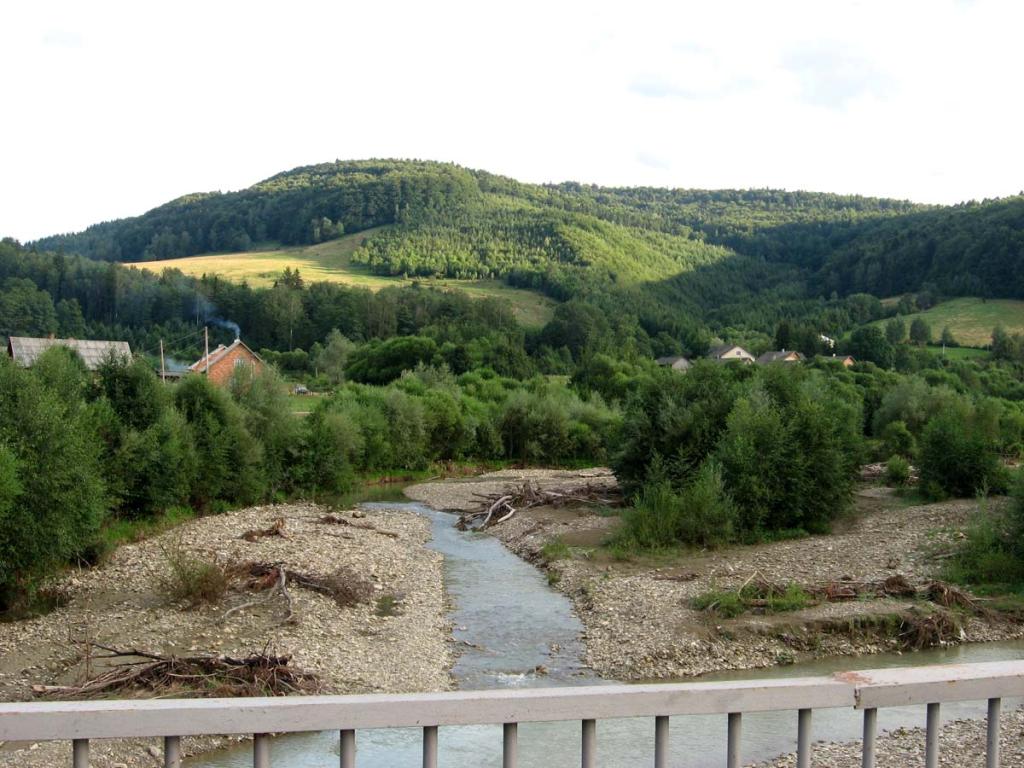
Storozhynets district is a district in the southwestern part of the Chernivtsi region of Ukraine, in the foothills of the Carpathians. The district center is the town of Storozhynets. The district is the largest in the region and covers 1160 km². The population is 97,965 people (as of February 1, 2012). The district is bordered by Romania in the south, Vyzhnytsia district in the west, Kitsman district in the north, Hlyboka district and the city of Chernivtsi in the east. The picturesque landscapes of the Carpathian foothills, which turn into mountains in the south and southwest, add to the region's unique beauty.
The city of Storozhynets is the administrative center of the district. Settlements of the district: Velykyi Kuchuriv, Ropcha, Krasnoilsk, Kostyntsi, Stara Krasnoshora, Verkhni Petrivtsi, Hlybochok, Budenets, Banyliv-Pidhirnyi. Accommodation there will provide housing in the private and hotel sectors for every taste and budget. Storozhynets has a very favorable geographical location. It is located on the Chernivtsi-Hlyboka-Storozhynets-Berehomet railway line with a branch from Karapchev to Chudey-Krasnoilsk. The town is crossed by the most important highways Chernivtsi-Storozhynets-Krasnoilsk, Hlyboka-Storozhynets-Vyzhnytsia, and Kitsman-Dubivtsi-Storozhynets. The city is located in a picturesque valley of the Siret River (a left tributary of the Danube). The region is characterized by landscape vegetation dominated by mixed forests.
According to archaeological materials, the settlement of Storozhynets already existed in the fourteenth and fifteenth centuries. The name of the settlement, as Yurii Karpenko proved, comes from the word "storozha," i.e. "guard." Initially, it was the name of a watch fortification, which may have been located on the hills along the left bank of the Siret. According to other sources, the name comes from the first settler named Storozh, who cleared a plot of land from a dense forest and settled here, near the Carpathian Mountains. In 1919, there was an attempt to rename Storozhynets to Flondoreny after the name of the landowner family that once owned the settlement, but the new name did not catch on.
History of the region
The Bukovyna region, including Storozhynets as its constituent part, has gone through a number of stages of development associated with the change of historical epochs, the formation and decline of states. For the first time in historical sources, Storozhynets was mentioned on February 18, 1448, in a charter of the Moldovan ruler Roman II. Obviously, the time of appearance of the settlement Storozhynets on the territory of Bukovyna should be attributed to the end of the XIV - beginning of the XV century. In 1476 the settlement was mentioned as the property of Todorahi Sorocanu. A charter of the Moldovan ruler Stephen III the Great dated March 15, 1490, shows that Storozhynets belonged to the Suceava parish at that time.
It is documented by historical research that in the ninth and eleventh centuries Kyivan Rus, and later the Galicia-Volyn principality (twelfth and thirteenth centuries), had administrative influence on the Bukovyna land. From the middle of the fourteenth century to the end of the sixteenth century. Storozhynets, like most of Bukovyna, was part of the Moldavian principality. In 1448, the town was ruled by the Moldovan voivode Roman. Later, Moldova became dependent on Turkey. The population bore the double oppression of the Turkish invaders and local Romanian and Moldovan feudal lords.
As a result of the Russo-Turkish War (1769-1774), the city was liberated from Turkish captivity, but eventually it was conquered by neighboring Austria-Hungary. After the fall of the Austro-Hungarian Empire, Storozhynets was ruled by the Royal Romanian Empire for 22 years. On June 28, 1940, Northern Bukovyna became part of the Ukrainian SSR and the USSR. In the same year, on November 11, during the administrative reorganization of the land, the Storozhynets district was formed. It has existed within its current boundaries since January 4, 1965. During the German-Romanian occupation, the district suffered enormous damage. The losses exceeded 67.0 million rubles at that time. Storozhynets was liberated from German occupation by the troops of the First Ukrainian Front in March 1944.
Festivals of the Storozhynets region
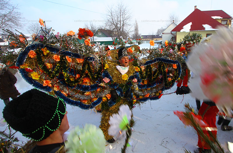
- Festival "From the Nativity to the Jordan". It is known in Bukovyna and beyond for the uniqueness of the Krasnoilsk Malanka. This large-scale phenomenon leaves absolutely no one indifferent with its originality, a combination of the past and the present. It is characterized by elements of clowning, props, and theatrics.
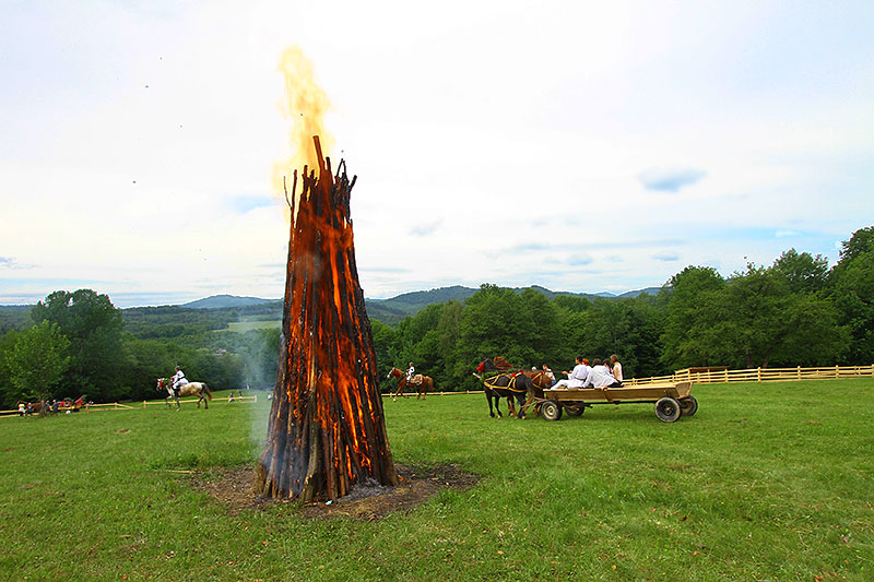
- Birch Sap Festival. The one-of-a-kind festival is held annually in the village of Banyliv-Pidhirnyi, Storozhynets district. Guests have the opportunity to taste fresh birch sap, take a master class on how to collect it, enjoy the nature of the Carpathian region, visit the Korolivskyi waterfall, taste Hutsul dishes and simply relax from everyday life in a pleasant and warm atmosphere.
- Festival Krasnoilsk Polonyna. The festival takes place in the village of Krasnoilsk, Storozhynets district (Bucharest road) and is gaining momentum every year. Everyone has the opportunity to admire the unique beauty of the Bukovyna Carpathians, taste local culinary delights, be enchanted by performances of original folk groups, dance in an incendiary national dance and enjoy the wonderful and unique atmosphere of the festival.
Monasteries of the district
The Monastery of the Holy Myrrh-Bearing Women (Verkhni Petrivtsi village, Leorda hamlet).
Construction began in 1994. Among the shrines are the icon of the Mother of God All-Holy Pantanassa, which is healing and helping; the Temple Icon of the Holy Myrrh-Bearing Women, which was painted in the Pochayiv Lavra; the icon of the Great Martyr and Healer Panteleimon with a piece of holy relics; A cross from Jerusalem, which was consecrated on the tomb of the Lord on Calvary; a cross made of cypress wood from Jerusalem with a part of the Cross of the Lord on which Jesus Christ was crucified. On the territory of the monastery there is St. Michael's Church, a new church under the bell tower in honor of the Great Martyr Panteleimon, and the Church of the Holy Myrrh-Bearing Women.
The Convent of the Holy Great Martyr John of Suceava (Krasnoilsk, Slatina village).
It was founded in 1996. It is here that the Solonets River originates from under a hill, where a well, which is still unique in its water composition, was equipped 200 years ago.
Museums and museum rooms
- Storozhynets Museum of Military Glory (25 Kobylyanska St., Storozhynets);
- Banyliv-Pidhirnyi Museum of Village History (Banyliv-Pidhirnyi village, gymnasium);
- Velykyi Kuchuriv Museum of Village History (Velykyi Kuchuriv village, secondary school building);
- Hodyliv Ethnographic Museum "Grandmother's Chest" (Hodyliv village, school premises);
- Novobroskivskyi Museum of Village History (Novi Broskivtsi village, administrative building of the village council);
- Nyzhni Petrivtsi Museum of Village History (Nyzhni Petrivtsi village, former school building);
- Krasnoyilsk Historical and Ethnographic Museum Ensemble named after M. Eminescu (a building on the territory of the church);
- Ropcha Museum of History and Local Lore (Ropcha village, village school building);
- Chudey Museum of National Cultures (Chudey village, premises of the village House of National Cultures);
- Kostyntsi Historical and Ethnographic Museum (Kostyntsi village, village school building);
- Davydivka Historical and Ethnographic Museum (Davydivka village, secondary school building);
- Ropcha Museum of Village History (Ropcha village, premises of the village House of Culture).
Cultural heritage
Architectural monuments of national importance
1) St. Michael's Church (Stara Zhadova village) - built in 1806. It is located behind the masonry on the right bank of the Siret River. The church was restored to its present appearance in 1954. The first priest was Pimen. Currently, the rector of the church is Kyrylo Pohorilovsky.
2) The Church of the Intercession of the Blessed Virgin Mary and the bell tower (Yaseni village) - built in 1748.
Architectural monuments of local importance
- St. George's Church (Storozhynets) - built in 1888;
- Roman Catholic Church of St. Anne (Storozhynets) - built in 1905;
- Town Hall (Storozhynets) - built in 1905;
- Church of the Assumption of the Blessed Virgin Mary (Bobivtsi village) - built in 1883;
- Tomb of the Medvedsky family (Bobivtsi village) - built in 1884;
- St. Michael's Church and Bell Tower (Budenets village) - 1803;
- Mikula's Palace (Budenets village) - nineteenth century.
- Paraskeva Church (Verkhni Petrivtsi village) - built in 1906;
- Paraskeva Church and bell tower (Davydivka village) - built in 1910;
- St. Dmitry's Church and bell tower (Yizhivtsi village) - built in 1897;
- Parish school (Kamianka village) - built in 1884;
- St. Michael's Church and Bell Tower (Kamianka village) - built in 1897;
- Church of St. John the Baptist (Krasnoilsk) - built in 1798;
- Church of the Assumption and bell tower (Mikhalcha village) - built in 1901;
- Church of the Blessed Virgin Mary and bell tower (Novi Broskivtsi village) - built in 1897;
- Holy Protection Church and bell tower (Nova Zhadova village) - built in 1897;
- St. Michael's Church (Panka village) - built in 1882;
- St. Demetrius Church and Bell Tower (Panka village) - built in 1900;
- Church of the Nativity of the Blessed Virgin Mary (Sloboda-Komarivtsi village) - 1924;
- Holy Spirit Church and bell tower (Sniachiv village) - built in 1877;
- Church of the Holy Apostles Peter and Paul (Stari Broskivtsi) - built in 1789;
- St. Demetrius Church and Bell Tower (Tysovets village) - built in 1892;
- St. Nicholas Church (Chudey village) - built in 1883.


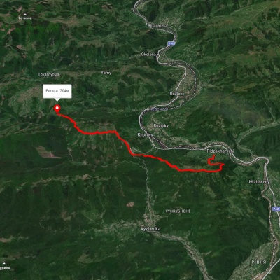
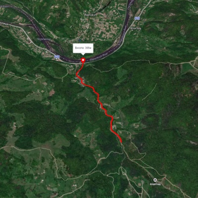
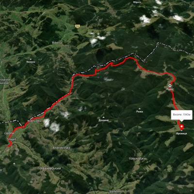
Which hiking trails pass through or near Storozhynets district?
We suggest these hiking trails through or near Storozhynets district: Nimchych Pass – Protiate Kaminnia, Smuharski Waterfalls, Shepit village – Mount Yarovytsia, Shepit village, via Mount Yarovytsia, Mount Pnivie and Mount Masnyi Pryslip to Shybene village, Nyzhnii Yalovets village, via Mount Yarovytsia to Shypit village, Shepit village, via Mount Yarovytsia, Mount Pnivie and Mount Tarnytsia to Probiinivka village