Velyka Syvulia weather
Summit 1836 m · Gorgany. Separate forecasts for the summit and the valley (Bystrytsia, 738 m). About the peak: Velyka Syvulia
Summit and valley
Hiking forecast for the route
Bystrytsia village, via Mount Tavpysh to Mount Velyka SyvuliaFresh wind up high, dry, 6…10° up high.
- Start at 8:00 — at the finish around 17:30
- Sunrise 7:32 · sunset 18:48
- 6:004°22 km/h
- 8:004°27 km/h
- 10:008°28 km/h
- 12:009°30 km/h
- 14:0010°29 km/h
- 16:009°26 km/h
- 18:008°23 km/h
- 20:006°28 km/h
Warnings
- Fresh wind up high — up to 31 km/h. The summit will feel colder than it looks from below.
In an emergency call 101 or 112Mountain rescue
What to take
- Three layers: base layer, fleece, wind- and waterproof jacket — 1° up high
- Hat and light gloves
- A spare warm layer: from 1° up high to 16° below
- A light rain jacket, just in case
- Hiking boots with a good grip
- Buff and glasses against the wind
- Tick repellent and long trousers; check yourself after the hike
- Water: 3.5 l per person — hardly any springs on the route
- A thermos of hot tea
- Lunch and snacks: nuts, dried fruit, chocolate
- Trekking poles — 1694 m of ascent
- Headlamp — sunset at 18:48
- Offline map or the GPX track of this route
- First-aid kit and an emergency blanket
- Charged phone and a power bank
Fog up high, rain, about 3 mm, wind up high to 29 km/h.
- Start at 8:00 — at the finish around 17:30
- Sunrise 7:33 · sunset 18:46
- 6:004°32 km/h0.7 mm
- 8:004°30 km/h0.4 mm
- 10:005°26 km/h0.3 mm
- 12:005°20 km/h0.7 mm
- 14:005°17 km/h0.5 mm
- 16:005°16 km/h
- 18:004°18 km/h
- 20:002°16 km/h
Warnings
- Clouds and fog up high — poor visibility, views are unlikely. Follow the waymarks and download the track for offline use.
- Rain — about 3 mm. The path will be wet and slippery on the descents.
In an emergency call 101 or 112Mountain rescue
What to take
- Three layers: base layer, fleece, wind- and waterproof jacket — −1° up high
- Hat and light gloves
- A spare warm layer: from −1° up high to 13° below
- Waterproof jacket — about 3 mm of rain
- Waterproof hiking boots
- Tick repellent and long trousers; check yourself after the hike
- Water: 3.5 l per person — hardly any springs on the route
- A thermos of hot tea
- Lunch and snacks: nuts, dried fruit, chocolate
- Rain cover for the backpack, things in a dry bag
- Trekking poles — 1694 m of ascent
- Headlamp — sunset at 18:46
- Offline map or the GPX track of this route
- First-aid kit and an emergency blanket
- Charged phone and a power bank
Chilly up high (−4°), dry, wind up high to 21 km/h.
- Start at 8:00 — at the finish around 17:30
- Sunrise 7:35 · sunset 18:44
- 6:000°20 km/h
- 8:000°22 km/h
- 10:002°18 km/h
- 12:005°20 km/h
- 14:006°21 km/h
- 15–216°19 km/h
- 21–33°8 km/h
Warnings
- Chilly up high — feels like −4°.
In an emergency call 101 or 112Mountain rescue
What to take
- Three layers: base layer, fleece, wind- and waterproof jacket — −4° up high
- Hat and light gloves
- A spare warm layer: from −4° up high to 17° below
- A light rain jacket, just in case
- Hiking boots with a good grip
- Sunscreen and sunglasses — UV index 3
- Tick repellent and long trousers; check yourself after the hike
- Water: 3.5 l per person — hardly any springs on the route
- A thermos of hot tea
- Lunch and snacks: nuts, dried fruit, chocolate
- Trekking poles — 1694 m of ascent
- Headlamp — sunset at 18:44
- Offline map or the GPX track of this route
- First-aid kit and an emergency blanket
- Charged phone and a power bank
Fog up high, rain, about 7 mm, chilly up high (−4°).
- Start at 8:00 — at the finish around 17:30
- Sunrise 7:36 · sunset 18:42
- 3–94°4 km/h2 mm
- 9–155°17 km/h5.6 mm
- 15–215°20 km/h2.6 mm
- 21–30°13 km/h
Warnings
- Clouds and fog up high — poor visibility, views are unlikely. Follow the waymarks and download the track for offline use.
- Rain — about 7 mm. The path will be wet and slippery on the descents.
- Chilly up high — feels like −4°.
In an emergency call 101 or 112Mountain rescue
What to take
- Three layers: base layer, fleece, wind- and waterproof jacket — −4° up high
- Hat and light gloves
- A spare warm layer: from −4° up high to 14° below
- Waterproof jacket — about 7 mm of rain
- Rain trousers or gaiters
- Spare socks in a waterproof bag
- Waterproof hiking boots
- Tick repellent and long trousers; check yourself after the hike
- Water: 3.5 l per person — hardly any springs on the route
- A thermos of hot tea
- Lunch and snacks: nuts, dried fruit, chocolate
- Rain cover for the backpack, things in a dry bag
- Trekking poles — 1694 m of ascent
- Headlamp — sunset at 18:42
- Offline map or the GPX track of this route
- First-aid kit and an emergency blanket
- Charged phone and a power bank
Fog up high, chilly up high (−7°), icy patches possible in the morning.
- Start at 8:00 — at the finish around 17:30
- Sunrise 7:38 · sunset 18:40
- 3–90°15 km/h0.2 mm
- 9–150°20 km/h0.2 mm
- 15–212°25 km/h
- 21–3−2°7 km/h
Warnings
- Clouds and fog up high — poor visibility, views are unlikely. Follow the waymarks and download the track for offline use.
- Chilly up high — feels like −7°.
- Around zero up high: rocks and roots may be icy in the morning.
In an emergency call 101 or 112Mountain rescue
What to take
- Insulated jacket over the fleece — feels like −7° up high
- Warm mittens, hat and buff
- A spare warm layer: from −7° up high to 11° below
- Waterproof jacket — snow up high
- Waterproof hiking boots
- Tick repellent and long trousers; check yourself after the hike
- Water: 3.5 l per person — hardly any springs on the route
- A thermos of hot tea
- Lunch and snacks: nuts, dried fruit, chocolate
- Rain cover for the backpack, things in a dry bag
- Microspikes — in case of ice
- Trekking poles — 1694 m of ascent
- Headlamp — sunset at 18:40
- Offline map or the GPX track of this route
- First-aid kit and an emergency blanket
- Charged phone and a power bank
Fog up high, light snow up high, chilly up high (−7°).
- Start at 8:00 — at the finish around 17:30
- Sunrise 7:39 · sunset 18:38
- 3–9−3°6 km/h
- 9–15−2°15 km/h0.6 mm
- 15–21−1°22 km/h1 mm
- 21–3−1°19 km/h0.2 mm
Warnings
- Clouds and fog up high — poor visibility, views are unlikely. Follow the waymarks and download the track for offline use.
- Light snow up high — the path may be slippery.
- Chilly up high — feels like −7°.
In an emergency call 101 or 112Mountain rescue
What to take
- Insulated jacket over the fleece — feels like −7° up high
- Warm mittens, hat and buff
- A spare warm layer: from −7° up high to 7° below
- Waterproof jacket — about 2 mm of rain
- Waterproof hiking boots
- Water: 3.5 l per person — hardly any springs on the route
- A thermos of hot tea
- Lunch and snacks: nuts, dried fruit, chocolate
- Rain cover for the backpack, things in a dry bag
- Microspikes — in case of ice
- Trekking poles — 1694 m of ascent
- Headlamp — sunset at 18:38
- Offline map or the GPX track of this route
- First-aid kit and an emergency blanket
- Charged phone and a power bank
Fog up high, chilly up high (−9°), icy patches possible in the morning.
- Start at 8:00 — at the finish around 17:30
- Sunrise 7:41 · sunset 18:36
- 3–9−2°16 km/h
- 9–15−2°15 km/h
- 15–211°19 km/h
- 21–3−3°8 km/h
Warnings
- Clouds and fog up high — poor visibility, views are unlikely. Follow the waymarks and download the track for offline use.
- Chilly up high — feels like −9°.
- Around zero up high: rocks and roots may be icy in the morning.
In an emergency call 101 or 112Mountain rescue
What to take
- Insulated jacket over the fleece — feels like −9° up high
- Warm mittens, hat and buff
- A spare warm layer: from −9° up high to 9° below
- A light rain jacket, just in case
- Hiking boots with a good grip
- Tick repellent and long trousers; check yourself after the hike
- Water: 3.5 l per person — hardly any springs on the route
- A thermos of hot tea
- Lunch and snacks: nuts, dried fruit, chocolate
- Microspikes — in case of ice
- Trekking poles — 1694 m of ascent
- Headlamp — sunset at 18:36
- Offline map or the GPX track of this route
- First-aid kit and an emergency blanket
- Charged phone and a power bank
Forecast: MET Norway (CC BY 4.0), temperature corrected for altitude; wind up high is an estimate for an open ridge. Updated at 22:21. A forecast is a guide, not a guarantee: mountain weather changes fast.
Open the route: Bystrytsia village, via Mount Tavpysh to Mount Velyka Syvulia
Routes to the summit
 HardTwo-dayUnmarkedBystrytsia village to Mount Velyka Syvuliavia Mount TavpyshElevation profile736–1 817 m20.1 kmascent 1 694 m≈ 8.5 h walking
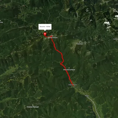 HardTwo-dayUnmarkedStara Huta village to Rushchyna polonynavia the Vodospadnyi Pass, Mount Velyka SyvuliaElevation profile670–1 834 m20 kmascent 1 854 m≈ 8.5 h walking
All summits
How we calculate
The data comes from the Norwegian Meteorological Institute (MET Norway). For every place we request the forecast at its own altitude: Hoverla is usually 8–10° colder than Vorokhta.
The hiking forecast looks at the whole route: start, highest part and finish, walking time from length and ascent, and daylight. It weighs thunderstorms, wind on the open ridge, rain, frost, heat, fog and snow.
It is a guide, not a guarantee. Check the forecast again before you go, tell someone your route, and in an emergency call 101 or 112.
