Mount Dzembronya
Mount Dzembronia, with a height of 1877 meters, is one of the most famous peaks of the Ukrainian Carpathians, located in the Carpathian National Nature Park on the border of Zakarpattia and Ivano-Frankivsk regions.
The mountain is located in the southeastern part of the Chornohora mountain range between two other equally famous Carpathian peaks: to the southeast is Pip Ivan Chornohora, to the northwest is Menchul.
Dzembronia is a pyramidal mountain consisting mainly of sandstones. The slopes of the peak up to an altitude of 1400-1500 m are covered with dense shrubs and centuries-old spruce forests, above this mark - with alpine and subalpine meadows, and in the summit part - mainly with stone placers.
Two rivers originate from beneath Dzembronia: on the southern slopes it is the Balzatul River, which is the right tributary of the Bila Tisa River, and on the western slopes it is the eponymous Dzembronia River, which later flows into the Black Cheremosh (its left tributary).
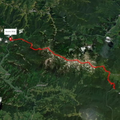
The road to Mount Dzembronia in the Carpathians begins in Berestechko. No, this village has nothing to do with the Berestechko where in 1651 Hetman Bohdan Khmelnytsky suffered a fiasco in a battle with Polish King Jan III Casimir. For the Hutsul region, this place name sounds rather strange. In Soviet times, it was decided that the Berestetska Dzembronia should be renamed Berestechko. This name, of course, did not catch on with the people.
Like most of the mountains in the Chornohora massif, Dzembronia is located on the border of two regions - Zakarpattia and Ivano-Frankivsk. Its height is 1877 meters. To the southeast of Dzembronia, you can see Mount Pip Ivan. It is easily recognizable - the remains of the Polish observatory, also called the White Elephant, are visible on the top.
The mountain is mostly covered with subalpine meadows. The Balsatul and Dzembronia rivers originate from the top.
It is worth noting that there is only one small house in the whole of Montenegro, and it is located on Mount Dzembronia: at the fork between Smotrych and Vuhatyi Kamen. However, there is one "but": in May-September, shepherds live here, grazing their numerous flocks on the ridge. Therefore, you can count on the hut being empty only in October-April (and then only if it is not occupied by other outdoor enthusiasts). Don't worry: the house is warm, and there is a stream nearby.
The nearest settlement is the village of Dzembronia, Verkhovyna district, Ivano-Frankivsk region.
You can get to Dzembronia from Verkhovyna or from the turn to the village of Iltsi. But keep in mind that if you take a bus near Iltsi, it may be full, and it will be difficult for you to travel with backpacks. You can, of course, "stop" the car. The way to the mountain is not close, so it is better to drive those few kilometers than to walk.

Accommodation around Mount Dzembronya:


Nearby hiking trails near Mount Dzembronya:
Which trails pass by Mount Dzembronya?
We suggest these hiking trails through or near Mount Dzembronya: Zaroslyak base, via Mount Turkul, Mount Dzembronia and Mount Pip Ivan Chornohirskyi to Shybene village, Dilove village, via Mount Pip Ivan Marmaroskyi, Mount Pip Ivan Chornohirskyi and Lake Nesamovyte to Zaroslyak base, Luhy village, via Mount Pip Ivan Chornohirskyi, Mount Rebra, Mount Hoverla, Mount Petros and Mount Sheshul to Kvasy village, Transcarpathian Tourist Trail, Shybene village, via Mount Pip Ivan Chornohirskyi, Mount Brebeneskul and Lake Nesamovyte to Zaroslyak base, Kvasy village, via Mount Petros and Mount Hoverla to Mount Pip Ivan Chornohirskyi


