Nadvirna district
Nadvirna district is located in the southwestern part of Ivano-Frankivsk region. 2/3 of the district's territory is located in the Ukrainian Carpathians, with less than a third falling on a conditional plain. The district center is the city of Nadvirna, and there are also major tourist locations such as Deliatyn, Dobrotiv, Bili Oslavy, Zelena, Pniv, Lisna Tarnovytsia, Lanchyn, Loieva.
The boundaries of Nadvirna district run along a winding line. The southwestern borders coincide with the borders of Ivano-Frankivsk region. In this area, the neighbor is Zakarpattia region, which is separated by the Polonyna-Vododilskyi ridge. The eastern neighbor of Nadvirna district is Kosiv and Kolomyia districts, the northern neighbor is Tysmenytsia district, the northwestern neighbor is Bohorodchany district, and the territory of Yaremche city council of Ivano-Frankivsk region is in the south.
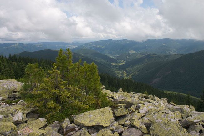
The following ranges of the Ukrainian Carpathians are located in Nadvirna district: Skibovi Horhany (Dovbushanka, Synyak, etc.), partially the Pokutsko-Bukovyna and watershed Verkhovyna Carpathians. The plain territory is located within the Precarpathian Upland (plain). The highest point of Nadvirna district is Mt. Dovbushanka (1754 m above sea level).
The district has significant mineral resources. Some of them are not yet developed or their development has been stopped. The fossil fuels are oil, gas, menilite shale; there are some ores of such metals as iron (Pasichna village), manganese (Liuchky river valley); placer gold (small content) in the Quaternary deposits of the Prut river tributaries; construction raw materials; amber (Delyatyn town); sodium and potassium salts (Delyatyn and Lanchyn towns); mineral waters, etc.
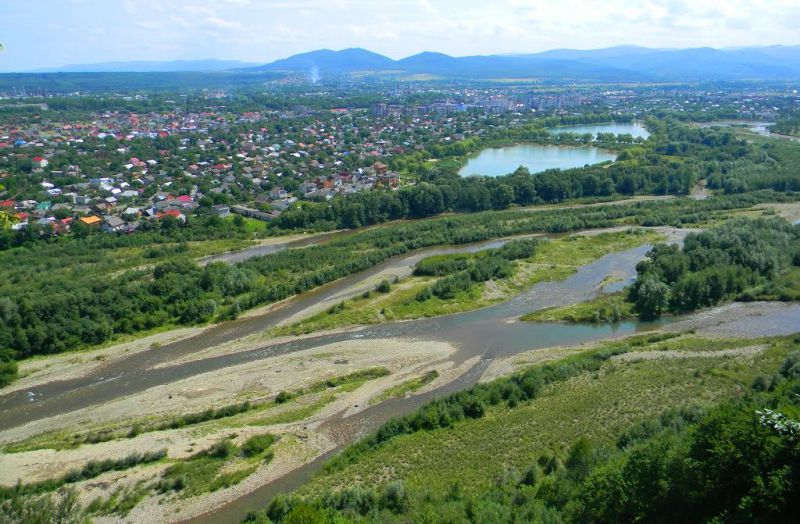
Nadvirna district is rich in water resources. The main rivers are the Prut, Bystrytsia Nadvirna, Vorona, Strymba, Liubizhnia, and Oslava. Within the district, the following main soil types and variations are distinguished: sod-podzolic-gley, sod, meadow, brown mountain-meadow, brown earth-podzolic, mountain-forest, and brown earth.
There are 5 railway stations in the district: Nadvirna, Tarnovitsa, Delyatyn, Lanchyn, Loieva. Population of the district: 115.4 thousand people (urban - 43.0 thousand, rural - 72.4 thousand). There are 47 settlements in the district, including 1 city, 43 villages and 3 towns. The territory of the district is 1.3 thousand km2. The distance to the regional center from Nadvirna is 37 km.
There are 146 monuments of different eras in Nadvirna district - from the Stone Age to the monuments built in our time. There are also archaeological sites in the district, from the Paleolithic period to the times of Kyivan Rus. Traces of burial grounds known as the Carpathian burial mounds culture, traces of Stone Age sites and settlements have been preserved in the area.
The Pozhyzhevska meadow (1429 m above sea level) is home to the highest mountainous workplace and scientific building - the biostationary of the Lviv Branch of the Institute of Botany of the National Academy of Sciences of Ukraine, built in 1899.
Castles
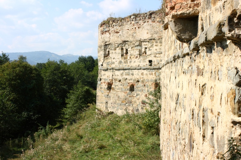
- The ruins of the Pniv Castle, the outskirts of Nadvirna.
- Remains of the castle on the territory of the city park (XV-XVI centuries), Nadvirna.
- UPA hideout, near the village of Zelena in the Chernyk tract. Here, on May 17, 1954, the commander of the UPA-West, Mykola Tverdokhlib (pseudonym Hrim), was killed. The UPA's fighting lost its centralized leadership, and this date is considered the end of guerrilla operations in western Ukraine.
- Castle remains (ramparts, moats), Dobrotiv village
- Territory of the former settlement, outskirts of Horodyshche
Museums
- Delyatyn local history museum.
- Museum of Nadvirna district history. Nadvirna, 43, T. Shevchenko Square. +38 (03475) 2-48-14, 9:00-17:00, SUN 11:00-15:00, SAT - day off.
- Mariyka Pidhiryanka Museum, Bili Oslavy village (the priest's residence), +38 (03475) 6-53-29 (to book a tour).
Wooden churches
- Church of the Exaltation of the Holy Cross (1835), Nadvirna
- The Nativity of the Blessed Virgin Mary (1785), Delyatyn village
- Miracle of St. Michael (1922-1925), Lanchyn village
- St. George the Victorious (1924), Bystrytsia village
- Immaculate Conception of the Blessed Virgin Mary (1746), Bili Oslavy village
- St. Dmytro (1835), village of Bili Oslavy
- St. Nicholas the Wonderworker (1906), Verkhniy Maidan village
- The Protection of the Blessed Virgin Mary (1854), Volosiv village
- St. Michael (1862), Havrylivka village
- St. Nicholas (1819), Hvizd village
- Assumption of the Blessed Virgin Mary (1739), Hvizd village
- St. Nicholas the Wonderworker (1876), Hlynky village
- Cathedral of the Holy Virgin (1895), Dobrotiv village
- Protection of the Holy Virgin (1943), Zarichchia village
- St. Dmytro (1796), Zelena village
- St. Paraskeva (1700), Kamynna village
- Saints Cosmas and Demian (1800), village of Lisna Tarnovytsia
- Transfiguration of the Lord (1835), Loieva village
- St. John the Baptist (1820), Nazavyziv village
- St. Nicholas (1803), Pererisl village
- Protection of the Holy Virgin (1912), Sadzhavka village
- St. Nicholas (1840), Strymba village
- St. Paraskeva Friday (1854), Tysmenychany village
- St. Paraskeva Pyatnitsia (1928), Fytkiv village
- St. Michael (1819), Tsutsyliv village
- St. Michael (1803), Chornyi Potik village
- St. Basil the Great (1863), Chorni Oslavy village
Waterfalls
- Bukhtivetskyi - on the river Bukhtovets, near the village of Pasichna - Bukove village (locally - Bukhtivets village). The first, small one is located right behind the bridge over the Bystrytsia-Nadvirna River in Pasichna village near the mouth of the stream of the same name. The next two are located almost next to each other - 6.5 km from the mouth of the stream in Bystrytsia or 50 minutes on foot without a load on a good dirt road, 50 meters from each other, in a picturesque canyon. Attention: Approach to the waterfall: from the waterfall sign, walk 20 meters close to the cliff, then find a steep path down on the right hand side. At the crossroads on the left you can reach the top of the waterfall.
- Salatruchil - is formed by the Salatruk stream, opposite the mouth of the Salatruchil stream (locally known as the Sixth Kilometer), which then flows into the Bystrytsia Nadvirna river 6.3 km from the village of Bystrytsia (Rafailova) at an altitude of 830 m. The waterfall is about 6 m high. From the Tavshpyrka ridge (the crossroads of the old border and the southern ridge trail) - 3 km and 600 m of elevation difference.
- Chernytsia - the waterfall on the Chernytsia stream is located at a distance of 5 km from the Nadvirna-Bystrytsia highway. There is a good dirt road to the waterfall.
Natural attractions
- Botanical reserve "Klyvskyi"
- Natural forests of white fir over 100 years old in the foothills of the Carpathians
- Tavpyshyrkivskyi Botanical Reserve
- High mountain spruce forests with an admixture of mountain pine and European cedar pine at the upper border of the forest
- Bredulets forest reserve. It is one of the largest massifs of the relict species of mountain pine in the Ukrainian Carpathians at an altitude of 900-950 meters above sea level.
- Verkhne Ozeryshche, a complex natural monument of national importance. A mountain basin with highland Carpathian virgin forests and subalpine meadows, spruce forests with beech and mountain pine mixed in.
- Vysokohirny arboretum, near the village of Bystrytsia
- Mineral spring, Rafailovets tract, Bystrytsia forestry (hydrogen sulfide water)
The district has a nature reserve "Gorgany" with an area of more than 5300 hectares, which is located between the villages of Bystrytsia, Zelena, Chernyk.


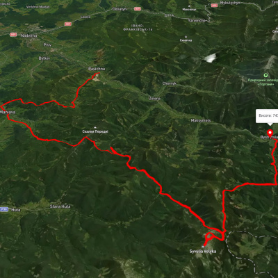
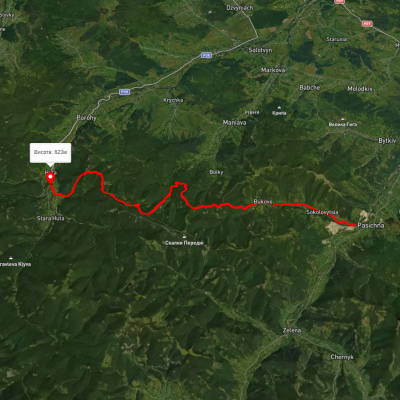
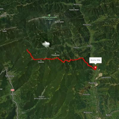
Які туристичні (пішохідні) маршрути проходять через/біля Nadvirna district?
Пропонуємо пройти такі туристичні (пішохідні) маршрути через/біля Nadvirna district: с. Пасічна, через с. Манява, Манявський вдсп., г. Велика Сивуля до с. Бистриця, с. Гута - с. Пасічна, с. Пасічна - пер. Переслоп, с. Пасічна, через г. Синяк, г. Малий Горган до с. Поляниця, с. Пасічна, через г. Синячка до м. Яремче, с. Дора, через г. Синячка, пер. Пересліп, пол. Туршугувата, хр. Явірник до м. Яремче