Stanislaviv Fortress, Ivano-Frankivsk
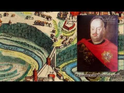
The city of Ivano-Frankivsk (formerly Stanislaviv) was founded in 1662 by Andriy Potocki, a representative of an ancient Galician noble family, on the site of the ancient Ukrainian village of Zabolotnia.
The fortress city was built in a short period of time (5 months) according to the project of François Corassini from Avignon (France) in the form of a regular hexagon with additional bastions, redoubts and a fort. The fortress was built according to the latest science of fortification, which no longer provided for traditional medieval towers, loopholes in the walls, and a battlefield for defenders on the inside. The bastions, outer pentagonal fortifications that allowed for flanking musketry along the walls, were located at the tips of the hexagon. The transverse section of the walls was an earthen rampart 20-30 meters wide, reinforced from the outside with oak logs. After 15 years of its foundation, the Stanislaviv Fortress was so strong that it was able to stop a huge Turkish army in 1672 and withstand a long siege.
The architect planned a street layout around a market square oriented to the cardinal points with a town hall in French tuas (1 tuas = 1.949 m). It was in these units that F. Corassini calculated the harmonious proportions of the main city square and the streets of the city center, which led to the city gates or intersected at right angles, forming a convenient system of communication between residential areas and strategic objects of the fortress.
Work on strengthening the Stanislaviv Fortress continued until the mid-eighteenth century. In 1679-1682, the engineer Karol Benoit improved the fortress in the direction of the newly built Potocki Palace. Around 1680, the fortress acquired a longitudinal plan. "Among all the Prykarpattia cities, Stanislaviv is the largest and most beautiful..... Its fortifications are striking in their perfection," wrote the French traveler François de Leran in 1687. In 1734-1750, the stockade was replaced with stone and brick, and the arsenal was completely rebuilt. The walls became brick, and the gates became stone. In total, there were seven large and small fortress bastions. The height of the fortress walls reached 10 meters. The fortress was surrounded by earthen ramparts, behind them stretched moats filled with water from the Bystrytsi River, and the city could be entered only through drawbridges that were lowered with the help of hand cranks, thus opening the city gates. From the south, access to the fortress was blocked by the Black Forest and a strip of continuous swamps.
The urban center was formed in accordance with a general plan that combined city quarters, the palace, and fortifications into a composite whole.
According to the ancient European canons of urban planning in cities that had Magdeburg law, the main square was Rynok Square with the town hall built on it, which was not only a self-governing body and a city decoration, but also a watchtower, the highest point of the fortress city, from which constant observations were made to see if the enemy was approaching the city and if a fire had broken out somewhere. The town hall itself housed the magistrate, court, and shops. The first building of the town hall was wooden.
At the same time, basements were constructed under the town hall, which were connected to numerous underground passages that, according to legend, had exits far beyond the city limits and stretched as far as ancient Halych. The basement premises had a military purpose and served as a prison.
In 1699, the construction of the stone town hall was completed. Each side of Rynok was densely built up with houses, which, as a rule, could not be higher than two, and later three floors and no wider than 3-4 windows. This was a requirement of the Magdeburg law tradition of urban planning and was dictated by safety considerations. The total area of the Rynok at that time was 9667 m2. It could accommodate almost 34 thousand people at the rate of 4 people per 1 m2.
The city was multinational. It was home to Ukrainians, Armenians, Jews, Poles, and Austrians, the percentage of whom varied over time. At the beginning of the eighteenth century, Ukrainians were the most numerous.
After the annexation of Galicia to the Austrian monarchy in 1772, the Stanislaviv Fortress lost its defensive significance. By an imperial decree of 1804, the walls were demolished, the fortress moats were filled in, and the ramparts were dismantled until 1870. Streets were laid along the filled-in moats, 4 squares and 24 streets were laid out of stone and brick walls, and residential buildings were built.
In the first half of the nineteenth century, three annual fairs were still held in the city. A wealthy merchant elite with quite a lot of capital stood out, living and building in the best quarters of the city. At this time, the city's layout underwent significant changes due to the demolition of the fortress.
Construction intensified even more in 1816, when trade and manufacturing revived. It was ordered that houses be built of stone and brick, and that old wooden buildings be dismantled, and that all roads and streets be paved with cobblestones.
The violent revolutionary events forced Emperor Ferdinand to sign a patent (decree) on April 17, 1848, "abolishing all serfdom and tribute in Galicia from May 15, 1848," with the landlords to be rewarded in the future at the expense of the state.
In the first decade after that, three industrial enterprises operated in Stanyslaviv. A locomotive repair plant, one of the oldest enterprises in the city, is currently operating near the railway station (22 Zaliznychna Street). Regular train traffic on the Lviv-Chernivtsi line began on September 1, 1866. There were 67 steam locomotives, 190 passenger cars, 115 freight and mail cars on this line.
In September 1866, the main workshops were put into operation, which were among the five largest industrial enterprises in Eastern Galicia at that time. The city also had many hotels, restaurants, and cafes. Branches of Viennese and Lviv banks were opened, and operations in the city savings bank (founded in 1860) increased.
In the second half of the nineteenth and early twentieth centuries, significant changes took place in the development of the city. New buildings, mostly three-story townhouses, replaced the old ones. In 1880, there were 1350 of them, about 500 of which were located in the city center. The center of the city remained the square near the town hall, from where the main streets diverged and connected with smaller ones. There were 45 streets and 10 squares and parks in total. The main streets had sidewalks and were paved. In 1876, street lights appeared in the city, first the train station and then the central streets were partially illuminated by gas lanterns.
The opening of railroad traffic became not only a factor of prestige for Stanislaviv, but also a factor of economic growth and tourism development. Mass travel to Pokuttya and Chornohora began. Tourists, ethnographers, and linguists began to visit the Hutsul region-Vorokhta, Yaremche, Mykulychyn, Zhab'ye, and other villages and towns. Ukrainians in Stanislaviv founded their own tourist society, the Chornohora.
At the beginning of the nineteenth century, the district starost was a German, Stanisław Franciszek Kratter. On his initiative, the first public garden was founded in the town, inaugurated in 1827, which was a favorite vacation spot for the townspeople. Today it is the area between Sichovykh Striltsiv and Hetman Mazepa streets. It was popularly called "Kratterivka".
In the middle of the nineteenth century, the number of Austrians among the residents was noticeable. Starting from the late eighteenth and early twentieth centuries, they worked as officials in the magistrate, starosta, were teachers of gymnasiums and schools, and built a church in the 70s of the nineteenth century.
Jews settled in Stanislaviv immediately after the city was founded. They received a separate privilege to do so on September 17, 1662. On the basis of this privilege, Jews were granted the right to "build and settle freely, to tearoom, to gendal and to earn a satisfactory living." In 1761, Jews built their first synagogue on Trinitarian Square, which burned down during a large fire in Stanislaviv. In the nineteenth and early twentieth centuries, the Jewish population in Stanislaviv grew significantly.
Armenians settled in the city in the 60s of the seventeenth century with the permission of Andriy Potocki. At the initiative of the Armenian brotherhood of Stanislaviv, a wooden church was built first, and later a stone church building. The Armenians were wealthy and engaged in crafts, in particular, the manufacture of sapphire products. They made a special contribution to the development of the city.
From the second half of the nineteenth century, Galician Ukrainians significantly intensified their national institutions. Starting in the 1970s, centers of various Ukrainian societies emerged in Stanyslaviv, following the example of Lviv, which was the center of the Galician-Ukrainian revival. The national centers were: "Prosvita, Plast, Sokoly, Ruska Besida, a branch of the Ukrainian Pedagogical Society, Teachers' Community, Society of Russian Women, Society of Craftsmen, and others.
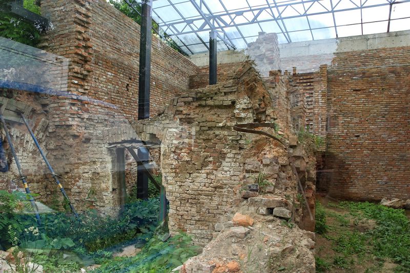
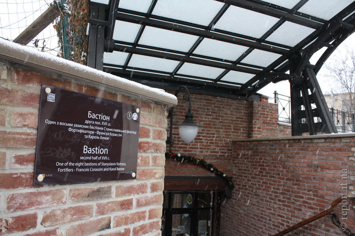
At present, two of the six bastions have no trace left, while three others can be traced quite clearly. One bastion has been largely preserved. Its remains are a brick wall in Fortechnyi Lane.
In 2002, a project to reconstruct the first bastion was launched, and it was decided to include it in the new project of the souvenir and gift gallery. Visitors to the gallery will be able to see the living history of our city - the old fortress walls, carefully restored and hidden under glass. The gallery project was designed by renowned architects who emphasized the great historical significance of this part of the city and the unique monument that is part of the project.
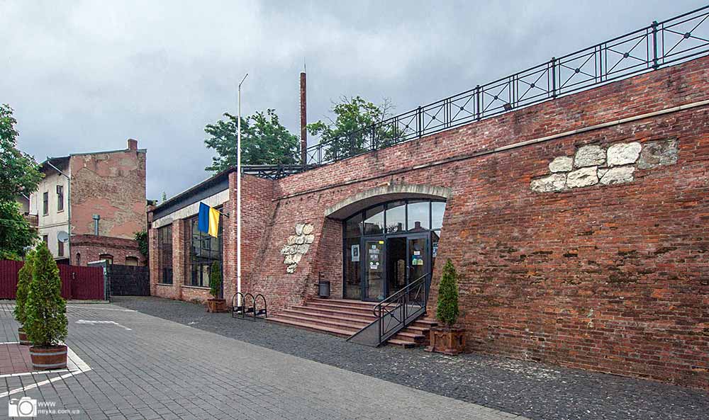
The Bastion Souvenir Gallery includes a coffee shop, a restaurant, a contemporary art gallery Art na Mur, shops selling ceramics and tableware, ethnic-style clothing, jewelry, handicrafts and jewelry making goods, paintings, perfumes and cosmetics, and other shops selling souvenir and gift items.
The gallery hosts changing exhibitions of various art forms: photography, painting, graphics, sculpture, etc. Literary readings and book presentations are held there. Various festivals are held on the square, including the international festival "Blacksmiths' Festival".
The gallery's favorable location contributes to its great popularity among residents and visitors. It is located in the historic center, where locals like to spend their free time and where local history excursions are traditionally held. The gallery's connection to the city center, Novhorodska Street and Sheptytskoho Square ensures a huge flow of people throughout the day.
The Bastion Souvenir Gallery is also included in the list of architectural monuments recommended for visiting by official delegations and tourist groups. Here you can watch a free movie about the history of the Stanislaviv Fortress and see living history - the old wall of the only surviving southwestern bastion and the casemates, which are preserved and hidden under glass.
Nearby are the City Hall, the Central Cathedral of the Holy Resurrection, the Museum of Local Lore, banks, cafes, etc.
Accommodation around Stanislaviv Fortress, Ivano-Frankivsk:


Which trails pass by Stanislaviv Fortress, Ivano-Frankivsk?
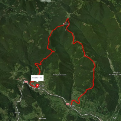
We suggest these hiking trails through or near Stanislaviv Fortress, Ivano-Frankivsk: Pasichna village, via Maniava village, Maniava Waterfall and Mount Velyka Syvulia to Bystrytsia village, Maniava village - Monastyretska polonyna, Dora village, via Mount Syniachka, Pereslip Pass, Turshuhuvata polonyna and the Yavirnyk ridge to Yaremche, Dora village, via Mount Syniachka and Pereslip Pass to Yaremche, Dora village, via Mount Syniachka and Chornohorytsia polonyna to Yaremche, Dora village, via Mount Syniachka and the Chornohorytsia ridge to Yaremche

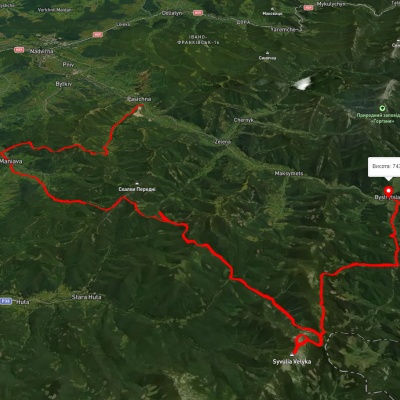
Pasichna village, via Maniava village, Maniava Waterfall and Mount Velyka Syvulia to Bystrytsia village

Maniava village - Monastyretska polonyna
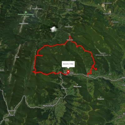
Dora village, via Mount Syniachka, Pereslip Pass, Turshuhuvata polonyna and the Yavirnyk ridge to Yaremche
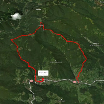
Dora village, via Mount Syniachka and Pereslip Pass to Yaremche