Mount Makovytsia, Yaremche
Thousands of people visit the Carpathians every year. Most of them come here to take a break from the city life and enjoy nature. Besides, these mountains have a certain mysticism about them. This also attracts tourists. One of these magnetic places is Mount Makovytsia, near Yaremche. It should be emphasized right away that this mountain should not be confused with Mount Makivka, which is near Slavske in the Lviv region.
There is a version that the name of the mountain comes from the word "makivka" - the top. Indeed, the top of Makovytsia offers magnificent views. According to another version, in Sanskrit, "Makovytsia" means a temple, a place where pagan sacrifices and worship of the gods were held. Now we know that there are two geological faults under one of the tourist routes. That's why the energy here is so strong.
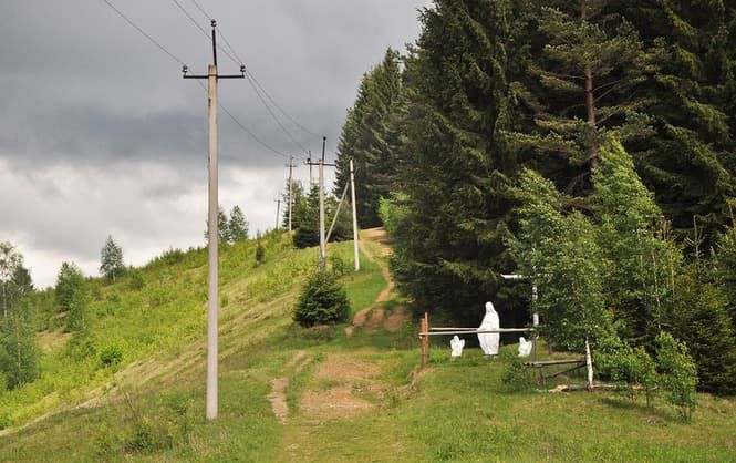
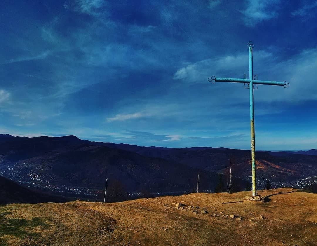
Locals say that in these places a person can be "caught by prodigality," meaning that they can lose their orientation in space and wander for a long time in the local forests. Perhaps that is why a wooden cross and a statue of the Mother of God with two angels were placed here.
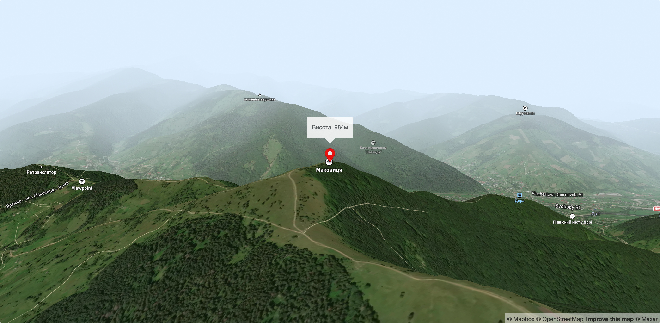
Makovytsia is one of the highest peaks in Yaremche and belongs to the Gorgany mountain range. It is located to the east of the central part of Yaremche within the Carpathian National Park. Although the mountain is quite low (984 meters), you can see the Yavirnyk, Khomyak, and Synyak mountain ranges from it . The treeless mountain peak offers a breathtaking panorama of the Carpathian Mountains, with the Kukulsky Ridge inthe south and the highest peaks of the Chornohora Range on the very edge of the horizon: Popivan, Hoverla, Petros. Around Makovytsia, the deep valley of the Prut River darkens on three sides, and the Dovbushanka ridge in the west . The top of Makovytsia and its slopes are crippled by trenches dug during the First and Second World Wars. During this period, heavy battles took place here. Historically, Mount Makovytsia and the surrounding area are known for the battles between the Austro-Hungarian and Tsarist armies in World War I. In memory of the victims, a cross is erected on the mountain.
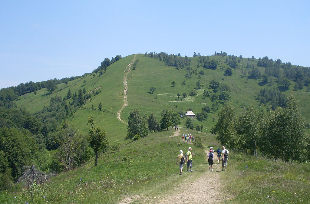
During the ascent, you will be greeted by berry thickets, hayfields and pastures. You will pass through the ancient forest, over the huge rocks where Oleksa Dovbush was hiding according to legend, and also come to an open meadow with a view of almost the entire territory of the national park.
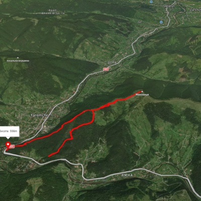
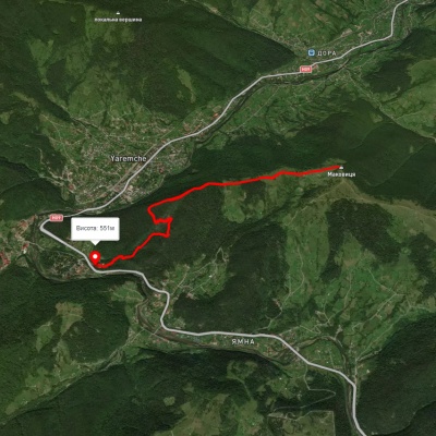
To the west of Makovytsia are the PrutRiver , the city of Yaremche, and the Zhonka River , which originates on the northern slope of the Yavirnykridge; to the south is the Prut River valley with the suburbs of Yamna, the village of Mykulychyn, and further on are the mountain peaks of the highest Montenegrin massif in the Ukrainian Carpathians . The nearest settlements are the city of Yaremche to the west, the suburb of Yamna and the village of Mykulychyn to the south, the suburb of Dora and the village of Delyatyn to the north, and the villages of Chorni and Bili Oslavy to the east. A metal cross and distance signs are installed on the top of the mountain: 3.5 km to the city of Yaremche, 3.5 km to the suburb of Dora, and 4.5 km to the Dovbush Cliffs.
The hiketo Mount Makovytsia is ideal for a beginner hiker. All trails are marked with signs, so it is almost impossible to get lost. There are several trails leading to the mountain - from Dora, Yamna (Yaremche suburbs) and from the parking lot near the souvenir market in Yaremche itself. The best choice is the latter: a winding path leads through an unusually beautiful beech-juniper-fir forest. The route is marked. The color of the mark is horizontal white stripes with a green stripe in the center. It starts from Ivan Franko Street, which turns into a mountain path and leads us to the very top. You can climb the mountain on your own on foot or on special jeeps or ATVs, renting them from locals with or without a driver.
After an hour of climbing, you will come across an observation deck that offers a great view of Yaremche. Then the trail enters a rocky area, passes by a repeater and leads to a clearing, from which it takes an hour to reach the top. In total, this hike will take about 3 hours of ascent and 1.5 hours of descent.
Just before the top there is a kolyba where you can order traditional Carpathian dishes. On the slope of the mountain of the same name is the Polonyna Makovytsia farm, where caring owners raise Carpathian sheep and make sheep cheese according to ancient Hutsul traditions. There is a shepherd's station here that operates from spring to fall. During this time, you can see a lot of sheep on the slopes of the mountain and buy a lot of cheese. In the meadow, they make ordinary and smoked budz, vurda, and bryndza. Here you can also learn about the true traditions of grazing the Carpathian sheep, whose peculiarity is that they produce a lot of milk. There are outbuildings on the meadow itself, which the locals call flocks. In the middle of the flock, a fire burns from May to September, where they cook food and process milk. Just imagine what a delicious meal cooked on wood! In addition to daily cooking, the shepherds collect sour cream from the milk, and then use the same technology that has not changed for centuries to make brynza (sheep's milk cheese) and vurda (whey and sheep's milk cheese). It is worth noting the high quality of the food, namely banosh, mushroom soup and dumplings, as well as the friendliness and politeness of the shepherds and owners of the kolyba!
On the way to Mount Makovytsia in Yaremche, there is a unique attraction - the trail to Dovbush's Rock. This short and easy route has been popular since the beginning of the XX century. It starts in the protected Dribka tract and runs between the rocks to the former Dovbush's Pantry cave (unfortunately, it was blown up in the 1940s). According to legend, it is here that the treasures of the "Carpathian Robin Hood" Oleksa Dovbush are hidden, but the entrance to the invisible cave can only be seen by a sincere and unselfish person, and will be indicated by a fern blossom on the night of Ivan Kupala. One legend says that during a battle with Polish soldiers, Oleksa Dovbush broke off a rock and threw it at the enemies, saving his comrades. According to another story, this stone has a secret: it has a carved portrait of Dovbush, which was created by a local artist to thank Dovbush for his help. However, to see the image of the avenger, the stone has to be turned over.
Dovbush's rocks are a unique work of nature. This place has long been a real tourist "mecca" for travelers. A unique pile of Yamnenska sandstone blocks has been frozen here since the Ice Age, which, through leaching and weathering, has created a fortress of a unique style. Of particular interest is the Dovbush stone near the highway and tunnel. The silent giant rises above the Prut River, shrouded in legends and tales. It is decorated with a stone cross, and the legendary opryshok seems to be sleeping under it. The Dovbush stone and rocks are natural objects associated with the name of the legendary leader of the national avengers Oleksa Dovbush, who operated in Prykarpattia in 1738-1745.
Dribka tract: The name comes from the word "crush", because the entire territory of the tract is covered with deposits of stone - Yamnenska sandstone, which has been mined ("crushed") since ancient times; 83 hectares of the tract, original stone compositions by Lviv sculptor Darii Hrabar dedicated to the liberation of Galician peasants from serfdom in 1848 and to the popular avengers, the opryshky, who operated in the Carpathians in the eighteenth and nineteenth centuries, places of growth of relict pine, the oldest of all species; the tree is 60-70 meters high, but its roots are almost on the surface, with which the pine clings to stones and reaches deep into the moisture.
Accommodation around Mount Makovytsia, Yaremche:


Which trails pass by Mount Makovytsia, Yaremche?
We suggest these hiking trails through or near Mount Makovytsia, Yaremche: Yaremche, via Dovbush Rocks and Mount Makovytsia to Yaremche, Yaremche, via Dovbush Rocks and Mount Makovytsia to Yaremche, Dora – Mount Makovytsia – Mount Staiky – Mount Smerichok – Dora, Yaremche – Mount Makovytsia, Yaremche, Dovbush Rocks and Mount Makovytsia to Yaremche, Mykulychyn village, via Mount Kostel, Mount Rokyta and Mount Makovytsia to Yaremche


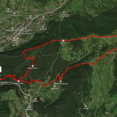
Yaremche, via Dovbush Rocks and Mount Makovytsia to Yaremche
Yaremche, via Dovbush Rocks and Mount Makovytsia to Yaremche
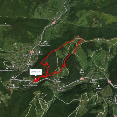
Dora – Mount Makovytsia – Mount Staiky – Mount Smerichok – Dora
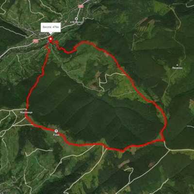
Yaremche – Mount Makovytsia