Carpathian National Nature Park
The Carpathian National Nature Park is located on the territory of Yaremche City Council and Verkhovyna district of Ivano-Frankivsk region. Area: 50495 hectares.
The Carpathian National Nature Park combines mountain and valley-river natural complexes typical for Chornohora and Gorgany, as well as valuable historical, architectural and ethnographic monuments. The area offers excellent conditions for scientific research, recreation and health improvement, promotion of environmental knowledge and environmental education.
The creation of the Carpathian National Nature Park was preceded by more than half a century of search and research. The idea of protecting the most valuable territories of the Carpathians originated in the early twentieth century. Thanks to thorough scientific research of the Carpathians, it was established that this mountain system is characterized by a special biogeographical originality, and that it has preserved virgin forest ecosystems unique for Central Europe.
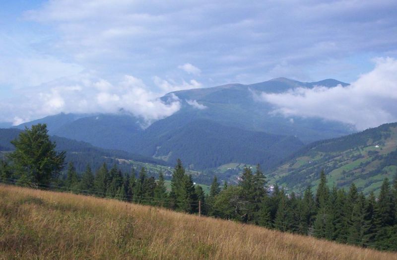
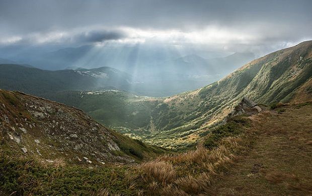
The highest ridge of the Ukrainian Carpathians is Chornohora, with an average height of 1850 m and a length of about 30 km. Six of Chornohora's peaks are over 2000 meters above sea level: Hoverla (2061m), Brebeneskul (2036m), Pip-Ivan (2022m), Hutyn-Tomnatyk (2018m), and Rebra (2001m). The main waterway of the park, the Prut River, originates at the foot of Hoverla at an altitude of about 1800 meters and absorbs numerous tributaries along the way: Prut Chemyhivskyi, Kamianka, Zhonka, Zhenets, Pihi, Prut Yablunytskyi, Homulets and others. The bottom of the Prut is uneven, rocky, and the current is fast, so there are many waterfalls and rapids on the river and its tributaries. The picturesquely beautiful waterfalls Probiy on the Prut River in Yaremche and Huk on the Zhenets River attract numerous tourists and "extremists" who dare to compete with the water element. Near the villages of Shybene and Dzembronia flows the famous Black Cheremosh river, which is sung in songs. Its largest tributaries are the Shybene, Dzembronia, and Bystrets. The park has two mountain "eyes" - lakes of glacial origin with eloquent names Nesamovyte and Maricheika. The first one is located on the southeastern rocky slope of Mount Turkul at an altitude of 1750 meters. Its depth is 1-1.5 m, and the area of the water mirror is 0.3 hectares. Lake Maricheyka was formed in a large glacial circus on the northeastern slope of Mount Shuryn Gropa at an altitude of 1510 meters. Its area is up to 1 hectare and its depth is up to 1 meter. There are about 800 natural springs in the park. The therapeutic sulfate, hydrocarbonate, calcium-magnesium, and other waters are of particular recreational value.
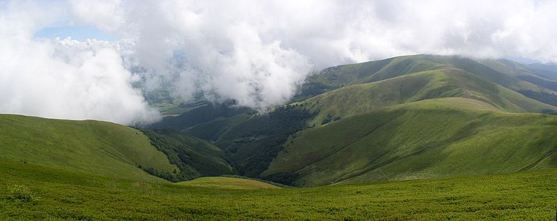
The park preserves the largest continuous massifs of mixed and pure spruce forests in the Ukrainian Carpathians, occupying altitudes from 1100 to 1600 meters above sea level. Above the spruce forests, there is a subalpine belt with its characteristic crooked forests of mountain pine (fir), green doucekia, Siberian juniper, and subalpine meadows, such as fescue, whitebark, and pike meadows. The alpine belt is located from 1850 to 2061 m, only in the areas of high mountain landscapes in the Chornohora massif. Their greenish-red monotony is diversified by small bright spots of grasses - yellow gentian, alpine bells, daffodil anemone, white sleep.
The park is particularly valuable for its spruce, fir, and beech virgin forests, which are 170 to 220 years old. This segment of wildlife has been preserved due to the inaccessibility and preservation of certain forest stands since the times of the Polish state.
The park's fauna is rich and diverse. There are about 200 species of vertebrates and about 600 species of invertebrates registered here. On the territory of the KNPP, the mammalian class is represented by 53 species, 11 of which are listed in the Red Book of Ukraine: alpine pika, lesser kutora, lesser horseshoe bat, lesser water mole (polecat), snow mole, ermine, European mink, badger, otter, forest cat, lynx, brown bear.
The park's employees have created appropriate conditions for recreation and rehabilitation of tourists, and have taken care of a network of ecological and scientific educational routes with a total length of more than 400 km. One of the most popular recreational destinations is the Vorotyshche recreation area, which is located at the exit from the village of Mykulychyn. In ancient times, back in the days of Danylo Halytskyi's reign, this was the guardhouse of the voivode Mykula. Among the many tourist routes, the Dovbush Trail is a special place of nature worship, and it is a very popular route among tourists. New stands that tell about the territory of the KNPP, the historical and cultural past of this region, small architectural forms, stone stairs and wooden railings that make it comfortable and safe for tourists to visit the trail - all this has made the route similar to the improvement of the best European hiking trails. The visit to the aviary is of great interest, especially its inhabitants - wild boars and red deer. The panorama of the majestic Ukrainian Carpathians will open up to those who will overcome the route "To Mt. Hoverla" route, which is 10.5 km long. In Yaremche, there is an amazing waterfall "Probiy", which noisily discharges its waters against the background of large stone blocks, creating an extremely majestic landscape of unusual beauty. A picturesque corner of the Gorgan massif is the Guk waterfall, where water falls freely from above about 15 meters, and the rich and beautiful forest nature is pleasing to the eye. In addition to interesting natural places, it is worth visiting the apiary and the facilities of the mountain meadow economy. The modern tourist and recreational base on the territory of the Carpathian National Park has medical and health complexes, houses and recreation centers, sanatoriums, educational, sports and tourist bases, tourist recreation complexes, children's health camps, private boarding houses, hotels, green tourism estates.
Since 2009, an ecotourism visitor center has been operating in the Carpathian National Park, which reflects a unique model of a Ukrainian national park that includes three key components: nature - the beauty and uniqueness of the natural landscape, history - the character and uniqueness of the historical and ethnographic environment, and religion - the sacredness and sanctity of local architectural monuments and religious buildings. This triunity was genetically embedded in the minds of the local Hutsuls, and has been passed down from generation to generation.
The Visitor Center was created thanks to the financial support of the European Union as part of the project "Creation of a cross-border network for the development and promotion of tourism between Ivano-Frankivsk region of Ukraine and Maramures county of Romania". The project was implemented by the Tourist Association of Ivano-Frankivsk Region in partnership with the Carpathian National Nature Park, Ivano-Frankivsk Regional State Administration, and the Ecologic Association, Romania.
The main purpose of the visit center in Yaremche is to promote the development of an attractive ecological and tourist image of the Carpathian National Park. Today, it is the only tourist attraction in Ivano-Frankivsk Oblast that represents not only the area but also modern environmental protection concepts in an attractive and interesting format for visitors. Here, visitors can access information about the region, protected areas, the richness of flora and fauna, the culture and way of life of local residents, and purchase information and promotional materials for free or at a reasonable price.
The recreation of the Chornohora range in the form of a model of mountain peaks with an altitude of more than 2000 m is quite original. There are also three dioramas depicting various elements of natural complexes of the near-water, forest and subalpine ecosystems (landscapes, flora and fauna, etc.).
There is also a composition of information stands (mountain meadow farming, Hutsul way of life and peculiarities of building a Hutsul house), a fragment of Hutsul housing and household items of local residents, which generally reproduces the ethnographic features of the Carpathian region.
This modern and functional facility, unique in Ukraine today, is designed to keep tourists in the region, maximizing their interest in the ecotourism attractions of the region. Therefore, we are pleased to invite residents and guests of our region to visit the visit center. You will be pleasantly surprised.
Accommodation around Carpathian National Nature Park:


Which trails pass by Carpathian National Nature Park?
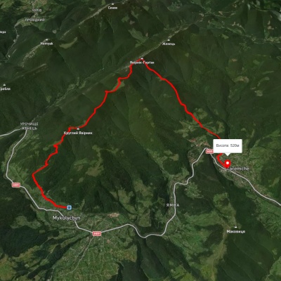
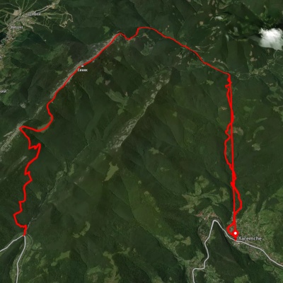
We suggest these hiking trails through or near Carpathian National Nature Park: Yaremche, via the Yavirnyk ridge to Mykulychyn village, Tatariv village, via Mount Khomiak, Mount Syniak, Mount Yavirnyk and Divochi Slozy Waterfall to Yaremche, Zhenets tract, via Mount Khomiak, Mount Syniak and Mount Malyi Horhan to Yaremche, Dora village, via Mount Syniachka and Pereslip Pass to Yaremche, Mykulychyn village, via Mount Yavirnyk to Yaremche, Polianytsia village, via Mount Syniak and Mount Yavirnyk to Yaremche


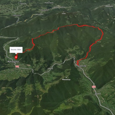
Yaremche, via the Yavirnyk ridge to Mykulychyn village

Tatariv village, via Mount Khomiak, Mount Syniak, Mount Yavirnyk and Divochi Slozy Waterfall to Yaremche
Zhenets tract, via Mount Khomiak, Mount Syniak and Mount Malyi Horhan to Yaremche
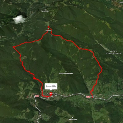
Dora village, via Mount Syniachka and Pereslip Pass to Yaremche