Saratoga
Sarata is a village in Ukraine, in the Chernivtsi region, Putyla district. It is known for being the most remote and inaccessible village in the Ukrainian Carpathians, with no normal road to reach it. It was founded in the early eighteenth century. In the best of times, Sarata's population reached 200 people. As of 2019, the actual population is about 20 people. Traditional folk crafts: wood carving,artistic embroidery,weaving.
Sarata is a village in the Putyla district of Bukovyna founded in the early 18th century and located near the village of Shepit. According to the last census, the population is only 20 people. The average height above sea level is 1182 meters.
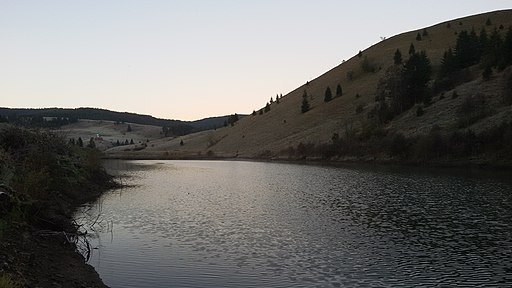
The main waterway of the village is the Sarata River of the same name, which is the right tributary of the White Cheremosh.
Mineral water springs have been discovered in this village. The clean mountain air and remoteness from civilization are the best opportunity to have a good rest.
Among the architectural monuments, the St. Elijah Church of the 17th century has been preserved. Unfortunately, it was not possible to find the exact year of construction of this church, which is similar to churches in neighboring Romania. It was probably built in the nineteenth century. The exterior was probably renovated in the 2010s. A few old cemetery crosses have been preserved near the church.
The church can be seen on a terrace of a low slope near the place where two rivers merge in the middle of this small settlement. It is a small three-domed one-story church with faceted side walls of the nave. As of 2008, its outer walls were still under shingles. It is not known whether and how often the church is used. At the entrance to the church grounds, a bell hangs on a wooden frame.
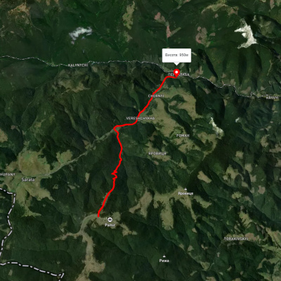
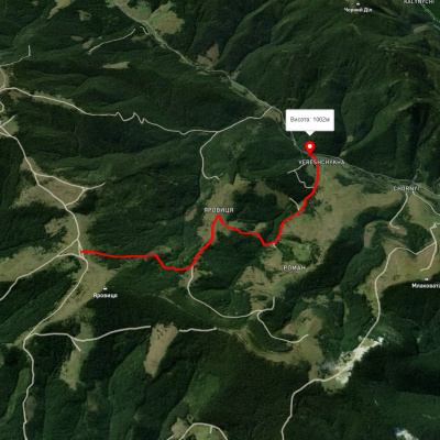
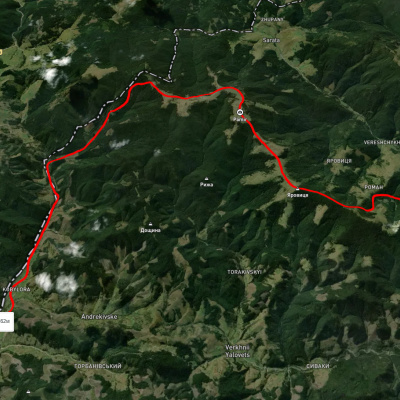
The most remote point, in the south near the border with Romania, is the village of Sarata. Logistically, it is much closer to Romania than to other villages in Ukraine. A small spot in the middle of the forest: 15 kilometers of a dead-end road from the remote village of Nyzhniy Yazlovets, further on to the source of the White Cheremosh and the famous Pamir. Further along the route, there are several villages in the foothills: Vyzhenka, Bahna, Chereshenka, Lopushna, Lukivtsi, Stara and Nova Zhadova. From Brusenky you will get to the mountains in Pidzakharychi. From there, climb up, first to the confluence of the two Cheremosh rivers, to the Bilyi Valley. Through the villages of Petrashi, Marynychi, Stebni, Shpetky, Dovhopillia, Konyatyn, Yablunytsia, you will reach the village of Holoshyna, where there are estates that welcome tourists. The road to Sarata often passes on the edge of deep sinkholes, 50-70 meters deep. For 15 kilometers from the turnoff in Nyzhnyi Yazlivets to Sarata, the road goes through the forest and can be flooded with water after rains. On a short section along the road, a wide strip of forest is cut so that the sun dries the road at least a little. Sometimes the calabans look more like lakes, and in some places they were so wide that you couldn't get around them on foot either - there was a river on one side and a very steep climb on the other.
In the wake of the development of green energy, under the pretext of routine maintenance, the dam was rebuilt to provide a mini-hydroelectric power station.
The local beautiful church impresses with its modern renovation. As it should be, it stands on a hill, and so it is clearly visible from everywhere. By the way, the church is functioning - the residents can hear the word of God, take communion, confess, etc. in their native village.
A large flock of sheep grazed near the church. The nearest store is 18 kilometers away, and in winter it is sometimes so covered with snow that you can only stay at home and wait for the spring to bring a grader. The boarding school in Selyatyn is 40 kilometers away or even closer through the Pamirs. The village of Sarata is really very interesting for its colorfulness.
Of course, there is no store or post office in a village with so few residents. But people are used to this and somehow manage. The basis of Sarata's economic life is their work on the land. Thank God, there is more than enough of it here. The houses are scattered several hundred meters apart. So, as much as you have the strength and desire, dig in your own plot. However, it doesn't produce much fruit - the altitude of the area, which is about 1100 meters, makes itself felt. So it is noticeably cooler here than in the foothills. The usual temperature in July is 15-18 degrees Celsius, while in winter the thermometer drops to minus 30 and below.
Under these conditions, there are no fruit trees in Sarata: neither apples nor pears ripen. Therefore, the villagers are mainly engaged in gardening: they grow potatoes, beets, and onions. Recently, however, the highlanders' diet has diversified: due to the warming weather, zucchini has begun to ripen.
Another important component of the farm is animal husbandry. Since the pastures are large, they can keep three to five cows. It turns out that there are more cattle in Sarata than people. The local cows are also peculiar - they go to the pasture by themselves and return by themselves. They don't give much milk, but it doesn't matter much, because there is no one to sell it anyway. So, the family uses almost all the milk for their own needs. In the fall, the number of cows decreases, and a truck comes to Sarata to take away the meat.
It is clear that the surrounding forests are full of mushrooms and berries. So, none of the residents go hungry.
They bake bread at home, and when they need oil or flour, they arrange with someone who will bring it. The distance to the nearest store is not that far, but it is not too far - it is possible to get there, even if it is a bad road.
Occasionally, Sarata is visited by tourists. It is good that there is a through road through the village. In particular, you can travel through Sarata from the village of Nyzhnii Yalovets to the village of Shepit. The distance to Nyzhnyi Yalovets is 20 kilometers, and to Shepit it is 18 kilometers. From time to time, locals cover these distances on foot.
So if you need a guide, you can find one. However, the Ukrainian-Romanian border is a stone's throw away, about five kilometers, much closer than the village of Shepit, whose administrative unit is Sarata.
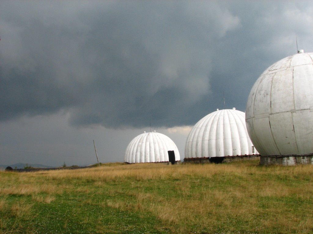
Among the local tourist attractions, the rather high Tomnatyk mountain, which is 4 kilometers away from Sarata, is worthy of attention. On the mountain itself there are huge and at the same time amazing balls. This place is called "Pamir" because it was the name of a radar station located here that operated during the Soviet Union.
So, it is safe to say that anyone who visits Saratov will not regret it.
Рекомендуємо відвідати в Saratoga


Маршрути поблизу Saratoga
Які туристичні (пішохідні) маршрути проходять через/біля Saratoga?
Пропонуємо пройти такі туристичні (пішохідні) маршрути через/біля Saratoga: Перкалаба - Томнатик, Верещиха - г. Яровиця, с. Нижній Яловець, через г. Яровиця до с. Шипіт, с. Шепіт, через г. Яровиця, г. Пнів'є, г. Тарниця до с. Пробійнівка, с. Шепіт – г. Яровиця, с. Шепіт, через г. Яровиця, г. Пнів'є, г. Масний Присліп до с. Шибене