Berehomet is an urban-type settlement of the Vyzhnytsia district. Today the population of the village is 7741 people. The Seret River flows through the village. There is a mountain Stizhok near the river. According to one theory, the name Berehomet comes from the German word Berg (mountain). According to another version, the name Berehomet comes from the fact that the Seret River "throws its banks".
The village has a gymnasium and 4 schools, Berehomet Polytechnic College, a driving school, a railway station, a factory, a forestry, a hospital, a town hall and a market. Private industry in the field of wood processing is developed. Berehomet has several landmarks associated with the life of the noble Vasylko family. Nature protection sites: Berehomet Park, Siretsky Nature Reserve (partially), Siretsky Rocks.
Berehomet has several sights associated with the life of the noble Vasylko family (Mykola Vasylko, a politician who devoted most of his life to defending the rights of Ukrainians in the Austrian Empire). The most striking building is the Vasylkiv Castle, which existed in the early twentieth century but has not been preserved in its original form. In the center of the village stands the stone St. Michael's Church (1888), which is directly related to the Vasylkiv family. The former summer residence of the Vasylko family (now the village hospital) has been preserved at 12 Tsentralna Street. In 1890, Mykola Vasylko founded the Berehomet Arboretum. It covers an area of 1 hectare and is home to 54 species of trees and shrubs. The pearl of the park is two trees of golden larch. On the way out of Berehomet towards Storozhynets, to the left of the road, there was a wooden church of St. George built in 1890 with a bell tower, which burned down on June 18, 2010. The administration of the Vyzhnytskyi National Park is located in Berehomet.
No one can say exactly when people began to settle Berehomet, but based on research, archival data, and legends, we can assume that it was no later than the fifteenth century. Why exactly then? In those ancient times, the Ottoman Empire was one of the most powerful states, and its rulers managed to conquer and subdue many countries. The Moldovan ruler who owned Bukovyna recognized himself as a vassal of the Turkish sultan. The people were brutally oppressed, forced to pay heavy taxes and perform various duties. Together with the Crimean Tatars, the Turks raided the lands of Bukovyna and Podillia, accompanied by murder, looting, devastation of settlements, enslavement of the people, and their sale into slavery. This misery intensified especially in the last quarter of the fifteenth century and continued into the sixteenth century. Historical chronicles tell us about the attacks of 1489, 1454, 1499, 1502, 1508, 1509, and 1515, which led to the flight of a large number of people to the mountains to save their lives and their children. The fugitive peasants tried to hide from their captors as far as possible, and therefore the best hiding place was considered to be the mountainous terrain, which was difficult to reach because of dense forests and sparsely populated places.
How many fugitives came there for the first time? There is also no answer, because no one took a census at that time. They chose this place not by chance, but because there was a river with large fish stocks, wood could be used to make houses, outbuildings, household utensils, and deer, wild goats, wild boars, hares, bison, mushrooms and berries could be harvested in the forest itself.
Obviously, there were several families who moved, because one or two would have been afraid to fight bears and wolves, which were plentiful in the area. In addition, it was difficult to make a log cabin alone, and one could not saw thick enough tree trunks. The dwellings were not large. They consisted of a hut and sheds and sometimes a barn for storing food, clothes, and other things. They tried to make everything like in the previous dwellings in the dales.
The furniture consisted of benches, a table, shelves, a bowl, and a cradle. There was no floor, small windows, a stove, a pail, a barrel, a poker, pots, icons with potions behind them, and some people had an embroidered towel hanging above them. In winter, animals could be inside with people. The house was dusty. Years and years passed. Little changed in the family life of the settlers. Mostly they hunted and gradually conquered the land from the forest, uprooting it. They rarely left their village for fear of meeting strangers or the army.
The population gradually grew. Children were born, new families were created, and the settlement was known in the Suceava cynut. The first written mention of Berehomet dates back to 1696 in the work of T. Balan "Documents of Bukovyna", which was published in Chernivtsi in 1937.
Representatives of various nationalities have long lived in Berehomet, given its position at the crossroads of various states of the time. The Jewish community of Berehomet in 1800 amounted to 10.8%.
Why was it called Berehomet? If we look at the grammatical basis, this word consists of two roots: bereg and met. What and who was throwing on the banks of the Siret? The materials of local oral folk art have preserved quite interesting facts from the lives of the people of those ancient times, and on the basis of this we can judge why they named their settlement so, and with minor modifications have been using this name for more than 15 generations.
There are two names for Berehomet: the folk and the official one. The folk or historical name is Voloskyi Berehomet, as many Wallachians (Romanians) lived here, and there was another Berehomet in the Kitsman district called Ruskyi Berehomet, i.e. Ukrainian. The official business name used in Austrian and Romanian records was Berehomet nad Siret, as there was a Berehomet nad Prut in the Kitsman district. During the years of Romanian occupation, the corruption "Berehomet am Siret" was used. The popular pronunciation is "Beregmit", "to Beregmeta", "Beregmitski". With the advent of Soviet rule, the distinction in name between the two Berehomet towns was erased.
The name Berehomet comes from the nature of the rivers on which the village is situated. Every spring, stormy streams made large banks of gravel. That's why people used to say "the banks were swept away" and the place was called Berehomet. The correctness of this theory is confirmed by the fact that there is no Berehomet outside of stormy rivers.
There is a legendabout the origin of Berehomet, according to which a peasant Vasyl lived in this area in the XV century and became famous for his exceptional courage during the war with the Turks. In gratitude, the Moldovan ruler Stephen III rewarded the brave warrior with land. Vasyl and his family settled on the banks of the Seret River at the site of the future settlement, and soon other families began to settle around him. Thus, the settlement grew, and at the end of the eighteenth century Berehomet became one of the most important centers of woodworking and salt production in Bukovyna.
In the nineteenth century, Berehomet became the fiefdom of the count Vasylko family, whose most prominent representative, Mykola Vasylko, remained in the history of Bukovyna as a politician who devoted most of his life to defending the rights of Ukrainians in the Austrian Empire. A native of the neighboring village of Lukavets, Vasylko received a prestigious education at the prestigious Vienna University, the Theresienwiese. Upon returning to Bukovyna, Vasyl was repeatedly elected village elder of Lukavets, and at the age of 30 he became a deputy of the Bukovynian Sejm, a regional self-government body. The deputy association "Free-thinking Union" that he created in 1903 drafted and pushed through a number of local laws in the Bukovinian parliament that contributed to the creation of genuine political and cultural autonomy for Ukrainians and other peoples living in Bukovyna. And in 1911, for the first time during the Austrian rule, Ukrainians formed a fairly large faction in the Bukovinian Sejm (17 seats out of 63), called the Ukrainian Klub.
In 1898 and 1907, Mykola Vasylko, while remaining a member of the Bukovyna Sejm, was elected to the Reichstag, the main Austrian parliament. Together with his associates from Bukovyna and Galicia, he formed the so-called Bukovynian Club in the parliament, which in 1911 became the Union of Ukrainian Ambassadors, a powerful faction of 29 deputies that firmly defended all-Ukrainian interests in Vienna until the collapse of the empire.
During the Ukrainian liberation struggle of 1918-1924, Mykola Vasylko was the representative of the government of the Western Ukrainian People's Republic in Austria, and after the "act of unification" between the two Ukrainian republics, he was the representative of the Ukrainian People's Republic in Switzerland and Germany.
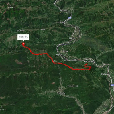
Even before entering Berehomet from Vyzhnytsia, one can see its distinctive landmark, the 784-meter-high Malyi Stizhok mountain. The mountain is associated with the legend of the leader of the peasant uprising O. Dovbush, who allegedly hid treasures looted from the rich here.
The peak itself is located on the right bank of the Seret River, and the town itself is stretched along its left bank for 12 kilometers. All of the town's sights are located on the main and longest street, called Central Street.
In the very center, at the corner of the road leading from Vyzhnytsia and Tsentralna Street, stands the stone St. Michael's Church, directly connected to the Vasylko family.
The church was built in 1888 at the expense of representatives of this famous family. Previously, an older church built by Oleksandr Vasylko in 1773 and moved to the village of Dolishnii Shepit in 1889 was located near the modern church on the site of the cemetery. An old memorial cross installed in the fenced area of the cemetery announces this fact.
The Berehomet arboretum was founded by Mykola Vasylko in 1890. Despite its neglected appearance, even today this monument of landscape art is unique. The park covers an area of one hectare and includes 54 species of trees and shrubs. The pearl of the park is two golden larch trees that grow only in the Yangtze River Delta in China. This is the only place in Ukraine where these rare exotics grow. Another unique natural exhibit of the arboretum is the Japanese double-lobed ginkgo tree. This is an ancient tree that even remembers the times of dinosaurs. Today, there are three trees of this species in the park. Fans of green nature will also see in the arboretum relict trees of the berry yew, camphor tree, and Canadian hemlock. The real decoration of the park is the tulip tree.
In addition to St. Michael's Church, Berehomet has a stone St. Nicholas Church built in 1897, located opposite the former estate. Given its location, we can conclude that it is also related to the Vasylko family.
The office of the National Nature Park "Vyzhnytskyi" is located in a two-story yellow building with a conical turret on the corner of the house at 27A Tsentralna Street. This park is the smallest national park in the Ukrainian Carpathians, but it is no less informative than the others. After all, it is the only one of its kind not only in the Bukovinian Carpathians, but also in the entire Bukovyna region.
The park covers an area of 7.9 thousand hectares and is located within the Vyzhnytsia district. The park was established in August 1995 in the lowland part of the Bukovinian Carpathians between the Cheremosh and Seret rivers in an area with a mild climate characterized by warm winters and mild summers, and the predominance of beech and fir trees in the forests. The landscape of the park is diverse: its eastern part, located in the Seretu basin, is occupied mainly by mountain ranges and wide valleys, while the western part is heavily dissected. There are many picturesque cliffs, steep slopes, gorges, and waterfalls.
There is an environmental and educational center in the park's management building, where you can learn more about the Vyzhnytskyi National Nature Park, watch slides and films, virtually visit all seasons, listen to the legend of the salamander, and a collection of natural sounds. The center organizes ecological routes through the park, some of which start in Berehomet. For example, the longest two-day sports route "From edge to edge" is 25 kilometers long and covers almost the entire territory of the national park. Starting in Berehomet, it passes through the Sukhyi tract, the Bankiv ridge, the pearl of green tourism, the village of Vyzhenka, and ends in Vyzhnytsia. Another route, Koromyslo, is 15 kilometers long, starting and ending in Berehomet, and runs through the Stebnyk and Sukhyi tracts. And the 18-kilometer-long Bozna sports and educational route involves climbing the 950-meter-high mountain of the same name, visiting the Stebnyk tract and a recreational area.
Walking along the main street of the town, it is impossible not to notice many old Austrian houses and former villas of the local rich.